
Everest Base Camp Trek: Top 10 Things to Do & Unforgettable Experiences
28 Mar 2026
Explore the top 10 Everest Base Camp Trek experiences, from Namche Bazaar to Kala Patthar, with stunning Himalayan views and rich Sherpa culture.
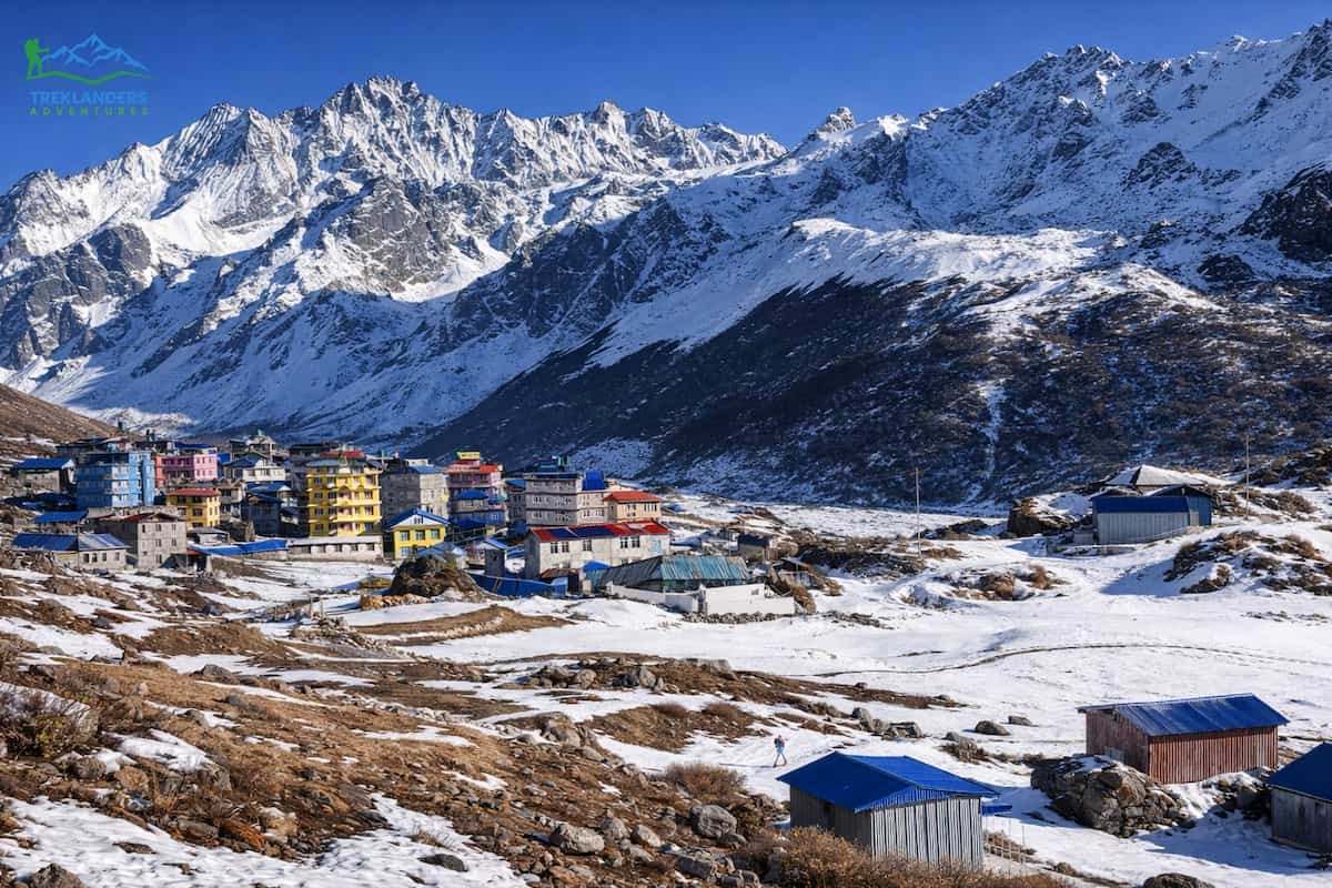
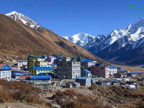
A day trip from Kyanjin Gompa to Lirung Glacier is the easiest way to see a glacier in Nepal. The starting point of the hiking day is a village at a very high altitude of around 3,870 meters, and you will be surrounded by mountains already. Thus, you will not have to work so hard to get to the glacier as compared to going on a trek that starts from a lower altitude. Along the way, you will have a great scenic view of Langtang Lirung, which is the tallest mountain in the Langtang region and the one that towers over the glacier. The trail is quite short, but it still demands a considerable amount of strength.
Along the way, you will be stepping on rocky ground, glacial debris, and other challenging paths. Since the oxygen level is low, even the slightly upward slopes will feel more difficult than you would expect. According to different factors such as the speed of the walk, the condition of the weather, and the level of acclimatization, most hikers take 4 to 6 hours to do the entire trip. It is not necessary to have technical mountaineering skills to complete this hike; however, you will need to have a secure footing and a good level of general physical condition.

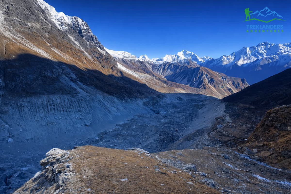
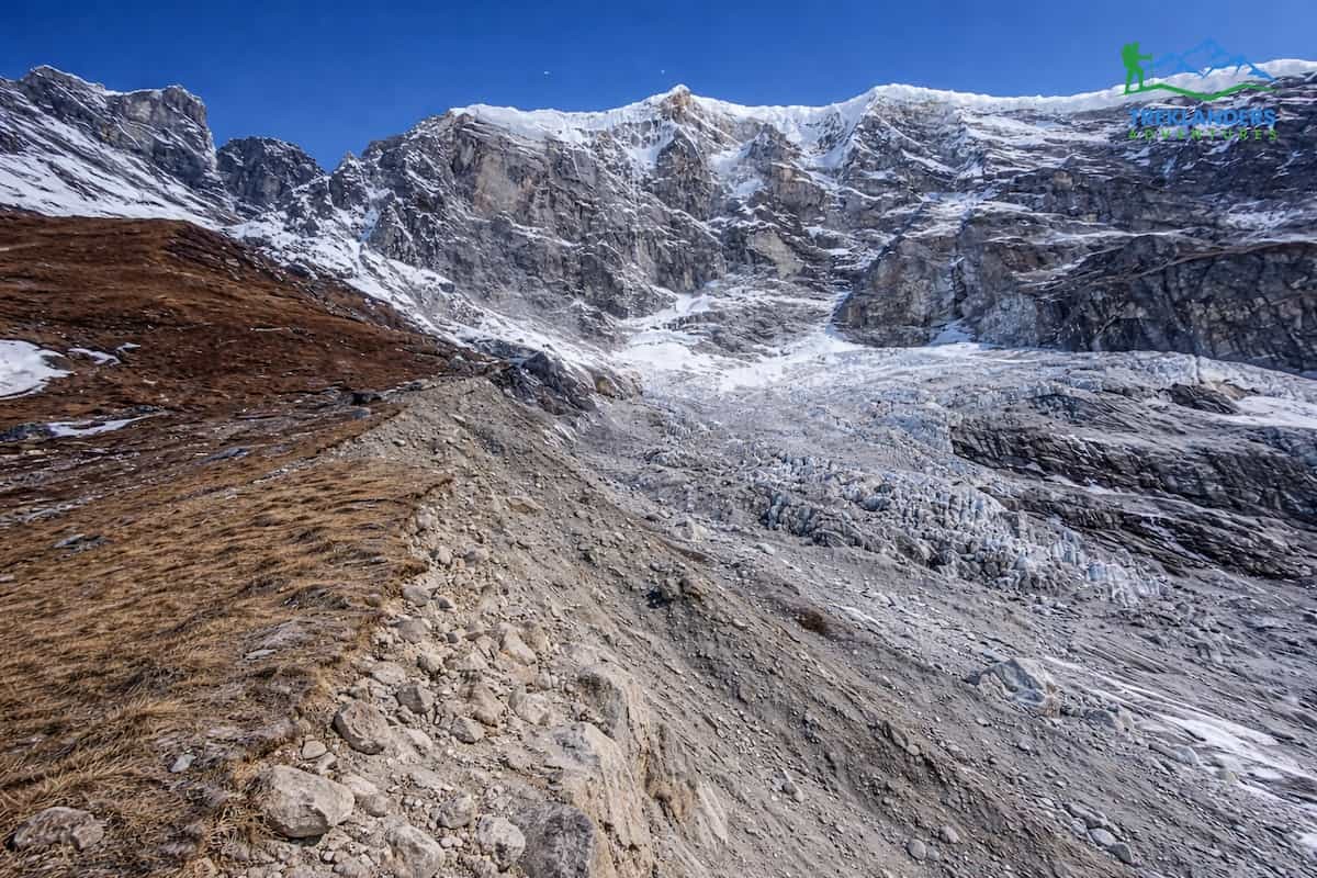
The first part of the trek takes you through open fields of yak grazing, and then you head to the glacier valley. As your altitude rises, the scenery changes drastically. The green areas are getting fewer and fewer. You will be in a dry, stony, and almost deserted landscape. You are likely to come across moraine ridges, scattered boulders, and glacial streams. The glacier shows itself as a combination of ice and rock rather than a perfectly white surface. This is the standard condition of Himalayan glaciers at the lower ends.
The weather will have a significant impact on this hike. Mornings are generally clear, allowing for great views of the glacier and the mountains. In the afternoons, clouds usually gather, and the wind gets stronger. The temperature can also fall rapidly, even if the sun is shining. You will require warm clothing, protection from the sun, and sufficient drinking water. There is no tea house or shop along the way, so it is necessary to carry your own provisions.
The foremost reason for people choosing this hike is the access. You can actually get right up to a genuine Himalayan glacier without a multi-day detour. The enormity only hits you once you are face-to-face with it. Ice walls, crevasses, and the constant sound of running water provide a raw setting. It is a totally different experience from regular viewpoint hikes such as Kyanjin RI or Tserko RI.
This hike could serve as a day for acclimatization or exploration in the Langtang Valley Trek. It diversifies your travel plan and provides you with first-hand interaction with the glacial environment, a hallmark of the high Himalayan regions.
| Category | Details |
| Starting Point | Kyanjin Gompa |
| Destination | Lirung Glacier |
| Region | Langtang Valley |
| Duration (Round Trip) | 4 to 6 hours |
| Distance | Approx. 6 to 8 km total |
| Starting Elevation | 3,870 meters |
| Max Elevation | Around 4,200 to 4,300 meters |
| Difficulty | Moderate to challenging |
| Trail Type | Out and back |
| Terrain | Rocky paths, moraine, glacial debris |
| Best Time | March to May, September to November |
| Water Sources | None on route, carry your own |
| Tea Houses | Not available on this hike |
| Guide Required | Not mandatory, but helpful |
| Main Highlight | Close view of Langtang Lirung and glacier |
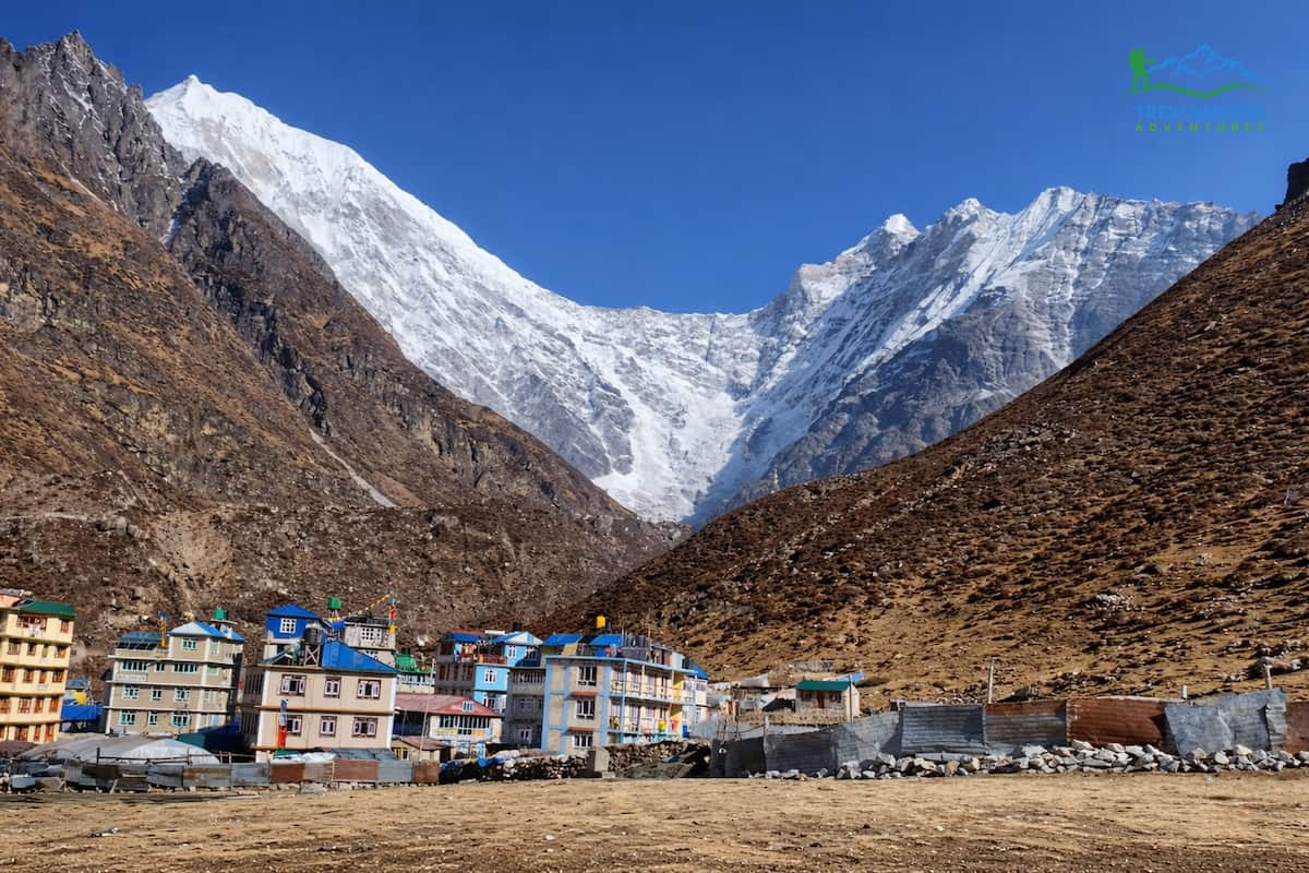
The path from Kyanjin Gompa to Lirung Glacier is a straight one on the map, but you need to be careful about the land and finding your way. There isn't one main trail for the whole walk. Instead, you use a mixture of barely visible paths, yak paths, and natural contours following the valley. From Kyanjin Gompa, you initially head north and go past open grazing areas.
The beginning part is quite straightforward. The terrain is broad and quite level, dotted with stones and grassy spots. In all probability, you will watch the yaks feeding in this vicinity. Further on, the valley shrinks, and the scenery changes from green to stony. At around half an hour to 45 minutes, the route becomes faint. You start to tread on glacial moraine. It is the rock debris left by the glacier over long periods.
Your footing is less certain, and you have to reduce your speed. Careful watching of every step is necessary, as you may slip on loose stones. No signposts exist, so you depend on visual direction. The glacier is still ahead, and Langtang Lirung serves as a very good landmark above it. The higher up you get, the tougher the land looks. Huge rocks and irregular ridges turn up.
At times, you might have to use your hands for support. Sometimes the path divides into several routes, but they all mostly lead in the direction of the same point. Where it's possible, stay at higher, more solid ground. Don't walk very near steep slopes or loose edges.
You will come across small glacial streams in some parts of your walk. These streams are normally shallow, but depending on the time of day, they can be cold and fast-moving. It is easier to cross them in the early morning as the water flow is lower. Since there are no bridges, you have to be very cautious when stepping on stones.
The last part of the walk to the glacier is a steady climb, but quite a tough one. You can notice the air getting thinner, and the vegetation disappears slowly. There comes a time when you can see the glacier ahead of you. It is not a smooth white area but rather a combination of ice, dirt, and rock. Generally, it is safe to go near the edge of the glacier; however, stepping on it is dangerous as there are definitely hidden crevasses and the ice is not stable.
You will return by the same path as you came. Going down will be quicker, but you will still have to be careful as you go along. The loose rocks are something that will make the walk downhill tougher, especially if you are already tired. Know that the wind generally picks up and the visibility decreases after the afternoon, so it is better to make it back on time.
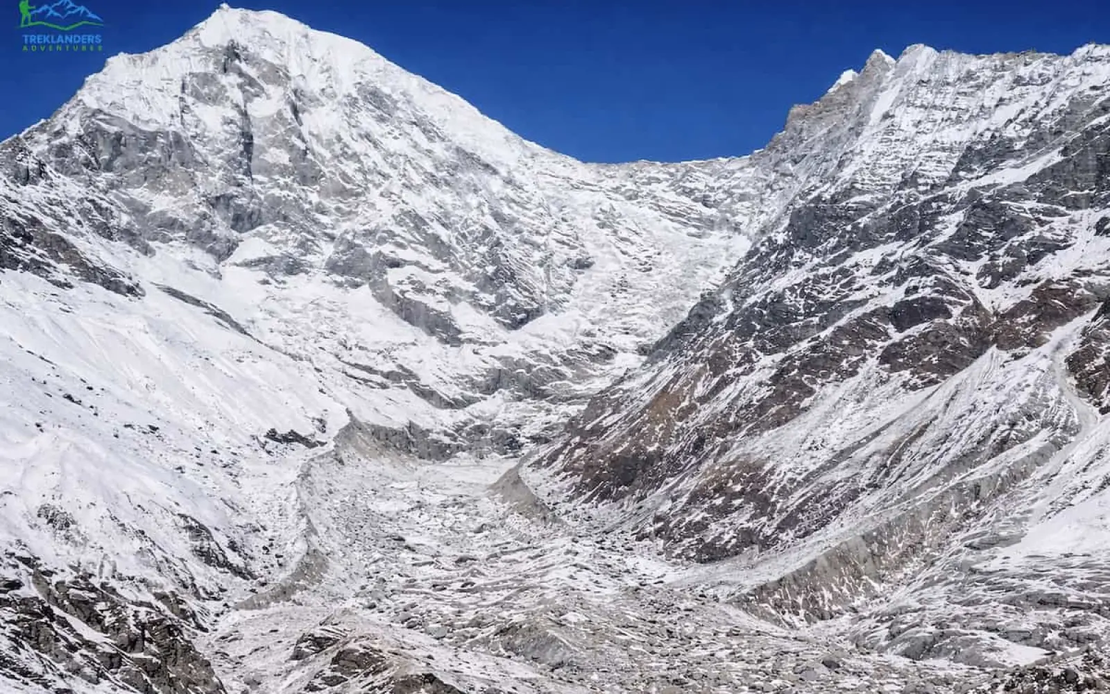
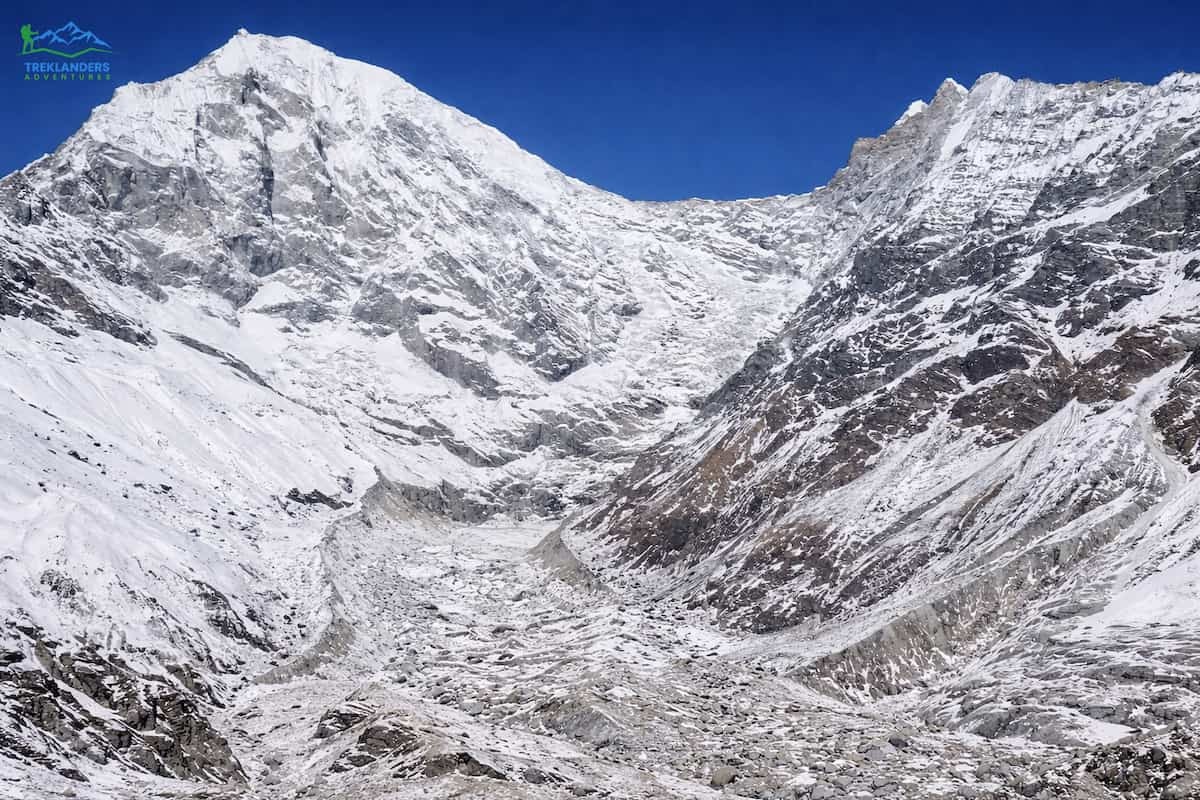
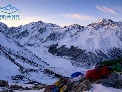
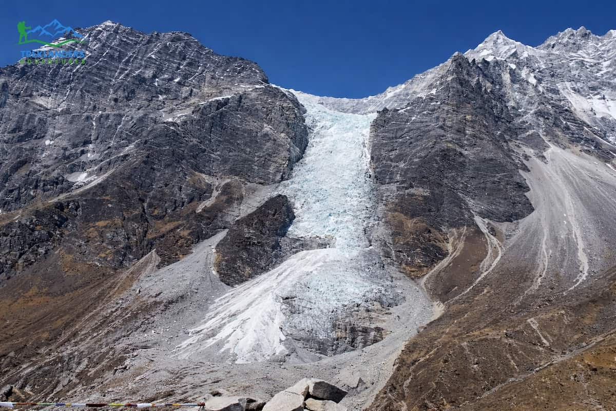
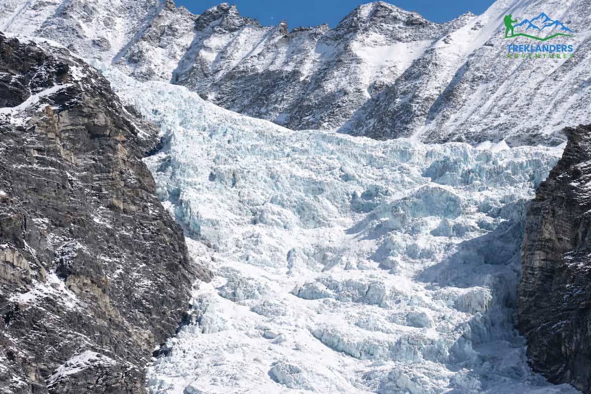
This makes the glacier seem like a whole, living organism. What strikes you first is its immense size. The glacier completely covers the valley floor and is surrounded by very steep rock faces and the enormous front of Langtang Lirung, the highest point visible, right above it. Being nearby means seeing glaciers with your own eyes extremely close up and in sheer detail. Lirung Glacier is located in the upper valley. Langtang Lirung peak presides over the scene, with ice and snow nourishing the glacier underneath. Some parts of the glacier's face have a glassy and somewhat translucent blue colour, particularly where between the ice and snow can be seen newly exposed surfaces. Quickly, you will realize that the glacier is not pristine or white.
The ice surface is so covered with stones, dust, and other debris that it looks dark and quite rough. However, when examining certain sections of the glacier that are either broken or where small walls are exposed, one can discern the ice layers underneath. Besides the huge and magnificent ice coverage, the glacier constantly produces the sound of flowing water. Water that is melting from the ice runs underneath or around it, making a quiet roar that you can always hear. The water from the ice forms running water in the rocks, which are initially just branching off as tiny rivers. As the day goes on and gets warmer, the amount of water increases. Besides the constant sound of water flowing, you may also hear the cracking and breaking of the ice.
Such changes and what appears to be breaking apart are only usual indicators of the glacier's reaming back and moving on. The rocky landscape actually surrounding the glacier is rather rough and uneven. Huge rocks, ridges, and loose moraine are the main types of features you will find all around the glacier. Almost no plants grow at this height. The place feels quite dry and uncovered. Often, the wind is blowing around the valley, making you feel as if the temperature is lower than it actually is. The weather, even on many sunny days, may change fast.
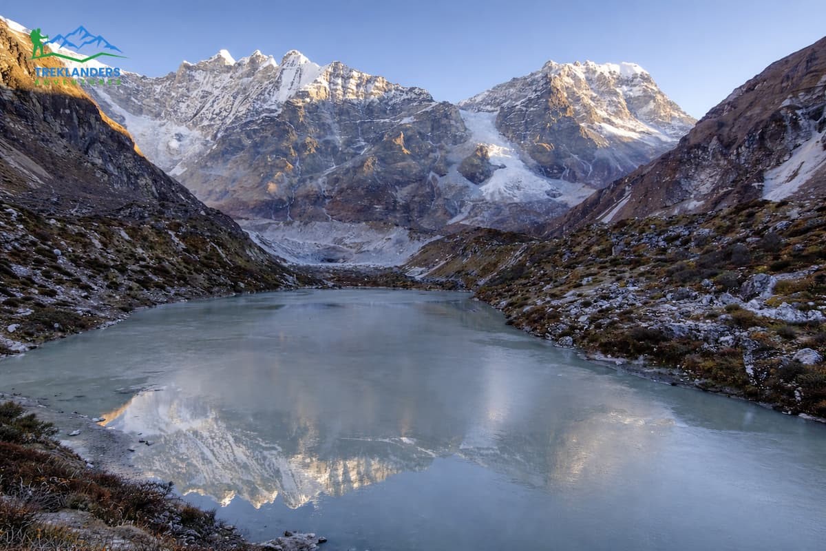
From here, you can also enjoy a much broader view of the upper Langtang Valley. When you look backwards, the valley stretches out toward Kyanjin Gompa, and the farthest ridgelines and snow peaks form layers in the background. At this spot, you can really see the difference between the green lower valley and the grey barren glacial zone.
You don't get to a single summit or viewpoint. Rather, the top is any safe glacier-adjacent point where you decide to stop. Usually, hikers spend 20 to 40 minutes here. You can take a break, snap some photos, and watch the scenery. It's best not to go further onto the glacier as there may be hidden crevasses, and the ice is unstable.
Here, the hike is raw and unfiltered as there are no buildings, no viewpoints, and no crowds. Here you are standing in a high mountain environment that has been formed by ice and time, and you have a direct line to the natural forces that make up the Himalayas.
The journey to Lirung Glacier provides a very different feeling compared to the ascents of Tserko RI and Kyanjin RI. The main difference lies in the experience. Glacier hiking is more about being close to the terrain and the glacier itself, while climbs to the RI’s are more about height and enjoying the broad views.
When going to Lirung Glacier, you remain in the valley. Instead of walking on a mountain top, you walk on rocky ground and moraine. Also, there is no mountain top or viewpoint marked. Here, the idea is to be near a glacier. You'll see ice, debris and active melt water from close quarters. The experience is more about the physical sensation of the ground. You have to deal with rocks that are not stable, surfaces that are not even, and you also have to find your own route.
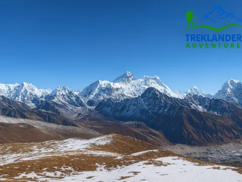
By comparison, the Tserko RI and Kyanjin RI are both steep climbs to high viewpoints. Kyanjin RI is shorter and more reachable. It usually takes about 2 to 4 hours round-trip, depending on where you start. The trail is quite obvious and heavily used. From the summit, you have a broad view of the Langtang Valley, the surrounding peaks, and the glaciers from above.
Tserko RI is a higher peak, and the hike is more challenging. You may need 6 to 8 hours for a round trip. The slope continues steeply upwards, and the air is getting thinner as you near the summit. On the other hand, you are rewarded with one of the most spectacular panoramic views in the region. You can see several Himalayan peaks in a complete 360-degree panorama.
Each route, with effort, feels different. The glacier hike is a much shorter distance, but the terrain is dragging you down. Doing it requires balance and a slow pace. RI hikes are longer and mostly uphill, which makes you test your endurance more than your pace.
Even safety considerations vary. On the glacier route, the main risks come from loose rocks, unstable ground, and getting too close to ice edges. On Tserko RI and Kyanjin RI, the risks are linked to altitude gain, fatigue, and exposure on steep trails.
Simply put, pick Lirung Glacier if you want to really see the Himalayan ice and the raw nature of the terrain. Go for Kyanjin RI or Tserko RI if you prefer the elevation, the structured trails, and the spectacular mountain views. Most hiker’s do both to experience the whole region.
It's ideal to hike from Kyanjin Gompa to Lirung Glacier during the two main trekking seasons in Nepal, which are spring and autumn. Both seasons provide weather stability, clear views, and safer trail conditions. Spring extends from March to May. At this time, temperatures start to rise as winter recedes. Walking conditions by day are quite pleasant, particularly when climbing to higher altitudes. Usually, the mornings are clear, allowing you to have a good view of Langtang Lirung and the glacier.
Winter snow could still be present on some parts of the trail, especially if you go in early spring. It makes the route a bit challenging in some places, but also so much more beautiful. At the end of April and in May, most of the snow is gone, and the trail opens up. Autumn goes from September to November. This is by far the best time to do this trek. You get very fresh air after the monsoon, and the mountain scenery shows up very well. The visibility level is, in many cases, at its highest.

The temperatures during the day are quite steady, normally ranging from 8 to 12 degrees Celsius around Kyanjin Gompa. However, at night it gets pretty cold, with temperatures frequently falling to the freezing point. The dry conditions of the trail make walking much more comfortable, even on moraine and rocky surfaces. October is the prime month for trekking because of the consistent weather and clear skies.
You should avoid the monsoon season, which lasts from June to August. Heavy rain affects the entire Langtang Valley. Trails become wet and slippery. Cloud cover blocks mountain views most of the time. Landslides can occur on the approach trail to Kyanjin Gompa, which increases travel risk. The glacier area itself also becomes less safe due to unstable ground and higher water flow.
Winter, from December to February, is possible but more challenging. Temperatures drop significantly, often well below freezing during both day and night. Snow can cover the route, making navigation harder. Ice forms on rocks, increasing the risk of slipping. The weather can change quickly, and strong winds are common in the valley. Only experienced trekkers with proper gear should consider this time.
For the best results, start your hike early in the morning regardless of the season. Clear skies improve visibility, and water flow from the glacier is lower. This makes crossings easier and the overall hike safer.
It is recommended to prepare yourself well in order to make a hike from Kyanjin Gompa to Lirung Glacier safe and efficient. Though the path is short, the environment will be high altitude and exposed. Even a small mistake can delay you or increase the risk level. Begin with acclimatization. After all, you are already at about 3,900 meters in Kyanjin Gompa. Plan to spend a night there at least before you implement your hike plan. If you experience symptoms of headache, nausea, or get very tired in an unusual way, cancel your plan for the day. Altitude severely impairs even short hike performances.
It is best to bring enough water. No dependable source exists on the path. You should prepare one and a half to two liters per capita. Dehydration is much easier at altitude, even under cold weather conditions. Along with this, take some basic food like energy bars or dried food. You will use up more energy than planned while negotiating the rocky parts.
Mind your footwear. Hiking boots with excellent grip and ankle support are advisable to wear. Along the way, you will have to deal with loose moraine and uneven rocks. People without good shoes stumble quite often. Trekking poles can be hugely beneficial in helping one keep their balance, especially on the way down. Dress in layers. Langtang Valley's weather is quite volatile.
Wear a simple base layer followed by a warm one, and always have a windproof outer with you. Even at times when you feel the sun on your face, the wind near the glacier may give you goose bumps. Gloves and a hat turn out to be handy, especially on the upper parts.
Start early. Leave Kyanjin Gompa in the morning when the sky is clear and the wind is not strong. Glacier melt increases as the day progresses, which makes crossing streams quite difficult. Early starting also allows you to have more time to move carefully without the need to rush.
Don't rely on marked trails. The path gets confusing after the first part. Basic map reading is helpful. Head roughly towards the glacier, keep Langtang Lirung in your line of sight for reference. If you are not sure about where to go, it is better to backtrack than to try to find your way by guesswork.
Keep a safe distance from the glacier edge. Don't get on the ice. You can't see the cracks and weak spots that are your 2 biggest risks. Only watch the glacier from safe ground.
Think about getting a guide if you don't have good navigation skills or if you have doubts about being at a high altitude. A guide, though not necessary, can still be a great help in terms of safety and also understanding the area.
Don't complicate your plan. Hike up, have some time by the glacier, and be back before the weather changes. By controlling your speed and going back early, you can avoid most of the problems on this trail.
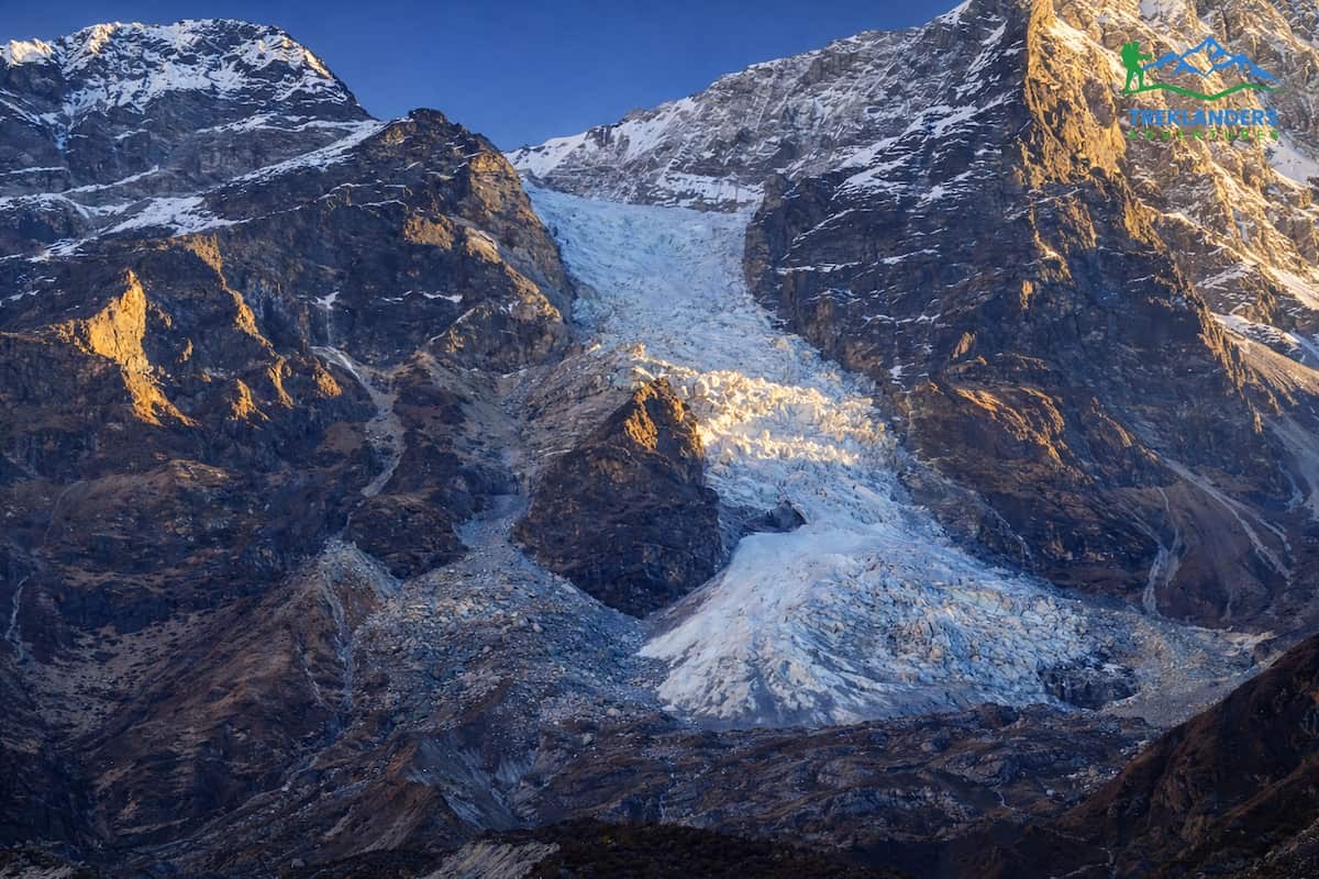
Lirung Glacier stands out as one of the largest glaciers in the Langtang area. It is positioned right under the Langtang Lirung peak (7,227 meters), which is the most visible element of the valley from the sky. The glacier is a result of the build-up of snowfall and ice from the mountain top slopes. This huge chunk of snow and ice gets packed up over time, and slowly the glacier creeps down to its current location, simultaneously modifying the surroundings through its path.
The glacier visible during the trek is the lower part, which is a debris-covered glacier, or simply, a glacier with a surface layer of debris. The layer covering the glacier surface is not solely composed of ice. It is a mixture of rocks, dust, and soil that has been transported down from the mountain top. This debris layer or mantle plays the role of thermal insulation for the ice beneath, and, in some places, melting gets inhibited while in others the ice gets exposed. Consequently, the surface has a filthy appearance, is uneven, and looks all rugged instead of pristine and smooth.
Lirung Glacier is a major contributor to the ecosystem of the area. It is the source of the melt water that gets into the small rivers coursing through the Langtang Valley. This water nurtures the plants, animals, and the local people residing further down. The quantity of melt water increases in the warm season and peaks in the late afternoon, correlating with the temperature rise. This everyday pattern can be perceived even during a very brief walk close to the glacier.
Just like other glaciers in the Himalayas, Lirung Glacier has been undergoing changes historically. Research and ground truth reveal that it is retreating due to the increasing temperature. The glacier's mass is being reduced gradually, and the present location of its front is behind the ones recorded in past decades. This scenario is not quite prominent if one visits only once; however, the naked rock and broader moraine zones definitely signify a long-term change.
The landscape near the glacier evidences a thorough glaciation. For instance, you will find moraines, which are accumulations of debris that have either been pushed or left behind by the glacier. Besides that, you will see tiny melt water streams running through the moraine. At times, you can even find bare glacier ice beneath very thin layers of rocks, which can illustrate to you the composition of the glacier under the surface.
Underneath its forbidding guise, the glacier operates as a living entity. Ice from higher points keeps trickling down, slowly feeding the areas that are melting at lower levels. This continual migration of ice is at the core of the sculpting of the valley and the changes it has made to the landscape around it.
In fact, Lirung Glacier can be a great starting point to understand these natural workings of ice and land for trekkers. It goes far beyond being merely a beautiful spot. It is, in fact, very much a living, breathing part of the Himalayan setting that in broad terms depicts the interaction of ice, rock, and climate at extreme altitudes.
The trek from Kyanjin Gompa to Lirung Glacier covers a short stretch of quite a marked ecological change. You are leaving the alpine pasture behind and entering a glacial, almost-barren zone. Changes in plant and animal life are very subtle at first, but by the end, they are quite clear.
To begin with, at Kyanjin Gompa, you find yourself in open grazing land. Such an area can support hardy alpine vegetation. Apart from the typical small low grasses, there will be moss and small shrubs that are adapted to cold and wind exposure. In spring, when conditions are right, some areas will be covered with short-lived wildflowers, but their population will not be nearly as dense as at lower elevations. The soil here is still moist enough to be able to support plant growth.
On the way up the valley, plant life and greenery diminish steadily. The ground becomes more and more stony, and the amount of soil is almost zero. Here, only the most tolerant of plants manage to live. You might see little cushion plants and various types of lichen stuck on rocks. These grow extremely slowly and are very hardy - capable of enduring strong winds, bright sunlight, and low temperatures. The fact that even such unpromising locations can have life is well demonstrated by their presence.
Although quite limited, animal life is around, but not very visible. The main animals you are likely to come across are the domesticated yaks. Local communities that herd them take care of them, and they graze in the lower parts of the trail. Yaks are natural high-altitude animals, and they are also quite good at moving around on difficult terrain. Be careful and give them space when you meet them on narrow paths.
If you pay attention, you might be able to spot some wild species at a distance. For example, the Himalayan tahr could be seen occasionally on steep rocky places. It can be quite difficult to see because it matches its environment so well, so you will probably have to look very intently. The blue sheep is another kind of wild animal you can spot in very quiet parts and at dawn, preferably when it is cool outside. It is said that the blue sheep or Bharal, as they are also known, usually live in larger groups and are found mainly on open stony ground where they can quickly see any approaching danger.
Birds, generally speaking, are visibly more lively and numerous than the large mammals in the area. Of the highest flying birds, the choughs are the ones that you are most likely either to see gliding high up in the sky or flying in small groups from one place to another. They have been equipped by nature to deal with less oxygen and usually hang around near cliffs and the tops of ridges. On the other hand, the smaller birds, changing along with the diminishing presence of greenery, mostly remain hidden from one's view as one goes higher up.
As you get closer to the glacier, it becomes clear that life is quite thinly spread and barely holds on. Most of the landscape consists of rock, ice, and wind. Just about any signs of vegetation almost vanish completely, and wildlife is seldom seen. One can call that higher part the end of the survival range for almost all living species.
Changing the habitat step by step from grass to glacier is your guide in comprehending how life in the Langtang Valley is regulated by altitude and the weather. Even if your trek is not very long, you manage to witness the entire conversion of a living world into a wild, untouched mountain one.
The day trek from Kyanjin Gompa to Lirung Glacier is a concise, high-altitude outing that does not take up much time. You do not require additional days or advanced technical skills. Exposure to the glacial terrain, transformation of the landscapes and magnitude of the Himalayas are among the things that you will most directly get from this short trip.
Even though the path is not very long, it needs your full attention. Uneven rocky surface, low oxygen level, and unpredictability in weather demand a slow pace and basic preparations. It is a great idea to begin the day early, bring an adequate amount of water with you, and have the correct garments for the weather. These steps are only a few; however, they do have a major effect on safety and comfort. However, what distinguishes this trek is closeness. Instead of just looking at the glacier from afar, you actually get to go close to it. You witness how the ice, rock, and water from the melting glacier come together.
In fact, it changes your trekking to Langtang Valley at a fundamental level, and you view the landscape's different side just by viewing the hike to the viewpoints Kyanjin RI and Tserko RI. This trek can easily be incorporated into most schedules. You will have a rest and still be able to take a hike for another half-day in the adjacent areas. Also, it can be an acclimatization exercise or an extra feature after making it to Kyanjin Gompa.
Conditions play a significant role. For example, clear mornings enhance both visibility and safety. The most stable weather is usually found in spring and autumn. One way to minimize the risk of accidents, e.g. in loose terrain or at a glacier edge, is to avoid going to such places under bad conditions.
The beauty of this trail lies in its practicality and efficiency. Visual effects can be so powerful that no additional kilometers are needed. If one happens to be in Kyanjin Gompa, the way to a Himalayan glacier by this route could be the most direct.

Explore the top 10 Everest Base Camp Trek experiences, from Namche Bazaar to Kala Patthar, with stunning Himalayan views and rich Sherpa culture.
Discover Dingboche (4,410m), the key acclimatization stop on the Everest Base Camp trek. Learn routes, altitude tips, and what to expect.

Explore the Gosainkunda Trek in autumn—clear skies, sacred lakes, and stunning Himalayan views with a short, high-altitude adventure near Kathmandu.