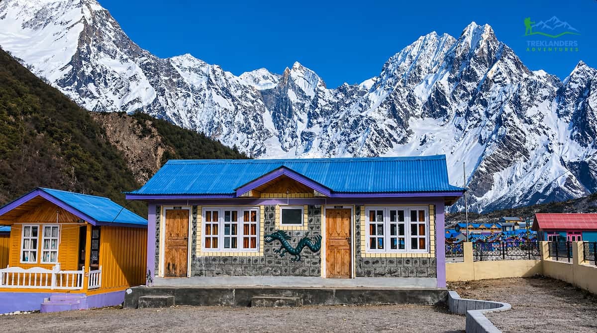
[{"name":"Everest Base Camp Trek","duration":"16","image_url":"https:\/\/www.treklanders.com\/storage\/trip-galleries\/1\/thumb_419a755c003cc609f3030ee332965ebe.jpg","offer_price":1405,"url":"https:\/\/www.treklanders.com\/trips\/everest-base-camp-trek"},{"name":"Gokyo Valley Trekking","duration":"16","image_url":"https:\/\/www.treklanders.com\/storage\/trip-galleries\/2\/thumb_676d1021b574aeba4d19d3f2a0b04ed2.webp","offer_price":1205,"url":"https:\/\/www.treklanders.com\/trips\/gokyo-valley-trekking"},{"name":"Annapurna Circuit Trek","duration":"23","image_url":"https:\/\/www.treklanders.com\/storage\/trip-galleries\/3\/thumb_2a9a92ea23c62f41de27b37f5e3e8c17.webp","offer_price":1495,"url":"https:\/\/www.treklanders.com\/trips\/annapurna-circuit-trek"},{"name":"Everest Panorama Trek","duration":"12","image_url":"https:\/\/www.treklanders.com\/storage\/trip-galleries\/4\/thumb_35c9f677ea2e88b1ff11a9f43daa3ddb.jpg","offer_price":1100,"url":"https:\/\/www.treklanders.com\/trips\/everest-panorama-trek"},{"name":"Everest Base Camp Trekking from Jiri","duration":"22","image_url":"https:\/\/www.treklanders.com\/storage\/trip-galleries\/6\/thumb_14763592492417b294aa66bf0ebf4e64.webp","offer_price":1400,"url":"https:\/\/www.treklanders.com\/trips\/everest-base-camp-trekking-from-jiri"},{"name":"Everest Base Camp via Cho la Pass from Gokyo Valley Trekking","duration":"18","image_url":"https:\/\/www.treklanders.com\/storage\/trip-galleries\/7\/thumb_d4e470e98d4e9e2ab8e93e39b8b7d252.jpg","offer_price":1405,"url":"https:\/\/www.treklanders.com\/trips\/everest-base-camp-via-cho-la-pass-from-gokyo-valley-trekking"},{"name":"Everest Three Passes Trekking","duration":"22","image_url":"https:\/\/www.treklanders.com\/storage\/trip-galleries\/8\/thumb_b413b221e913171500bb3dfd5c08ceea.jpg","offer_price":1635,"url":"https:\/\/www.treklanders.com\/trips\/everest-three-passes-trekking"},{"name":"Annapurna Base Camp Trekking","duration":"14","image_url":"https:\/\/www.treklanders.com\/storage\/trip-galleries\/9\/thumb_2e71f2ffe116c659fa66b01c2d571b4e.webp","offer_price":845,"url":"https:\/\/www.treklanders.com\/trips\/annapurna-base-camp-trekking"},{"name":"Mardi Base Camp Trekking","duration":"14","image_url":"https:\/\/www.treklanders.com\/storage\/trip-galleries\/10\/thumb_d7b2d2dc638f6bbf2c31c167ac68029d.webp","offer_price":845,"url":"https:\/\/www.treklanders.com\/trips\/mardi-base-camp-trekking"},{"name":"Mohare Danda Trekking","duration":"12","image_url":"https:\/\/www.treklanders.com\/storage\/trip-galleries\/11\/thumb_a384c8d35d789d29b19991c1d675c910.webp","offer_price":755,"url":"https:\/\/www.treklanders.com\/trips\/mohare-danda-trekking"},{"name":"Khopra Ridge & Khair Lake Trekking","duration":"15","image_url":"https:\/\/www.treklanders.com\/storage\/trip-galleries\/12\/thumb_c0f50461ddc74acfb553ba85be00fab0.webp","offer_price":855,"url":"https:\/\/www.treklanders.com\/trips\/khopra-ridge-khair-lake-trekking"},{"name":"Upper Mustang Trekking","duration":"17","image_url":"https:\/\/www.treklanders.com\/storage\/trip-galleries\/13\/thumb_7aa4dfdb69186b0f224a303d80a25c95.jpg","offer_price":1715,"url":"https:\/\/www.treklanders.com\/trips\/upper-mustang-trekking"},{"name":"Langtang Valley Trek","duration":"12","image_url":"https:\/\/www.treklanders.com\/storage\/trip-galleries\/14\/thumb_8650b4b1a3c160cff75da65369398353.webp","offer_price":735,"url":"https:\/\/www.treklanders.com\/trips\/langtang-valley-trek"},{"name":"Gosainkunda Lake Trek","duration":"11","image_url":"https:\/\/www.treklanders.com\/storage\/trip-galleries\/15\/thumb_bfe94c14e760c48234e117021105be84.webp","offer_price":735,"url":"https:\/\/www.treklanders.com\/trips\/gosainkunda-lake-trek"},{"name":"Chisapani-Nagarkot to Dhulikhel Hiking","duration":"7","image_url":"https:\/\/www.treklanders.com\/storage\/trip-galleries\/16\/thumb_468defe9a4000ee3129cd7e6421ee105.webp","offer_price":565,"url":"https:\/\/www.treklanders.com\/trips\/chisapani-nagarkot-to-dhulikhel-hiking"},{"name":"Kanchenjunga Trek","duration":"23","image_url":"https:\/\/www.treklanders.com\/storage\/trip-galleries\/17\/thumb_51f43fa4203106cc49aaedc89d76e01d.jpg","offer_price":1725,"url":"https:\/\/www.treklanders.com\/trips\/kanchenjunga-trek"},{"name":"Helambu Trek","duration":"12","image_url":"https:\/\/www.treklanders.com\/storage\/trip-galleries\/18\/thumb_0fe8e3fa1299d2e43bf1fb5977875ce2.jpg","offer_price":685,"url":"https:\/\/www.treklanders.com\/trips\/helambu-trek"},{"name":"Upper Dolpo Trek","duration":"26","image_url":"https:\/\/www.treklanders.com\/storage\/trip-galleries\/19\/thumb_d6080d490e1db83b0a711e7304000864.jpg","offer_price":3005,"url":"https:\/\/www.treklanders.com\/trips\/upper-dolpo-trek"},{"name":"Manaslu Circuit Trek","duration":"18","image_url":"https:\/\/www.treklanders.com\/storage\/trip-galleries\/20\/thumb_1fdd224e849f4f328e73d2d12b3d282d.jpg","offer_price":1225,"url":"https:\/\/www.treklanders.com\/trips\/manaslu-circuit-trek"},{"name":"Tilicho Lake Base Camp Trek","duration":"19","image_url":"https:\/\/www.treklanders.com\/storage\/trip-galleries\/21\/thumb_eba8ac5e029e6543e0c17630ebd9e2fb.jpg","offer_price":1220,"url":"https:\/\/www.treklanders.com\/trips\/tilicho-lake-base-camp-trek"},{"name":"Nar-Phu Valley With Thorang-La Pass Trek","duration":"21","image_url":"https:\/\/www.treklanders.com\/storage\/trip-galleries\/22\/thumb_43597423a5a366fe9c8937fb30d2fe2a.jpg","offer_price":1315,"url":"https:\/\/www.treklanders.com\/trips\/nar-phu-valley-with-thorang-la-pass-trek"},{"name":"Nepal Round Trip of Kathmandu-Pokhara-Lumbini and Chitwan Tour","duration":"10","image_url":"https:\/\/www.treklanders.com\/storage\/trip-galleries\/23\/thumb_32497d170b2ab340b0a1b3310e91e784.webp","offer_price":845,"url":"https:\/\/www.treklanders.com\/trips\/nepal-round-trip-of-kathmandu-pokhara-lumbini-and-chitwan-tour"},{"name":"Nagarkot Day Hike","duration":"2","image_url":"https:\/\/www.treklanders.com\/storage\/trip-galleries\/24\/thumb_a5a654930fd8ba7852e41738105bacfc.webp","offer_price":105,"url":"https:\/\/www.treklanders.com\/trips\/nagarkot-day-hike"},{"name":"Nagarkot Sunrise Tour","duration":"1","image_url":"https:\/\/www.treklanders.com\/storage\/trip-galleries\/25\/thumb_17dc28a29cfa44381ad503f0a75ee84f.webp","offer_price":22,"url":"https:\/\/www.treklanders.com\/trips\/nagarkot-sunrise-tour"},{"name":"Namobuddha Day Tour with Shiva Statue","duration":"1","image_url":"https:\/\/www.treklanders.com\/storage\/trip-galleries\/26\/thumb_beeb34202f9077764aa08c67ef2867f9.webp","offer_price":45,"url":"https:\/\/www.treklanders.com\/trips\/namobuddha-day-tour-with-shiva-statue"},{"name":"Kathmandu Full Day Sightseeing Tour","duration":"1","image_url":"https:\/\/www.treklanders.com\/storage\/trip-galleries\/27\/thumb_d045fc0f1acee2cfa6b3c95f3c656d18.jpg","offer_price":30,"url":"https:\/\/www.treklanders.com\/trips\/kathmandu-full-day-sightseeing-tour"},{"name":"Patan and Bhaktapur Sightseeing Tour","duration":"1","image_url":"https:\/\/www.treklanders.com\/storage\/trip-galleries\/28\/thumb_750eacac3424b5dba686dd93656ab87c.jpg","offer_price":30,"url":"https:\/\/www.treklanders.com\/trips\/patan-and-bhaktapur-sightseeing-tour"},{"name":"Upper Mustang Heli Tour","duration":"1","image_url":"https:\/\/www.treklanders.com\/storage\/trip-galleries\/29\/thumb_0b785f69a15557f8660c805c76fda14e.webp","offer_price":1250,"url":"https:\/\/www.treklanders.com\/trips\/upper-mustang-heli-tour"},{"name":"Everest Heli Tour","duration":"1","image_url":"https:\/\/www.treklanders.com\/storage\/trip-galleries\/30\/thumb_dc45f2beb36a3699e0decf0de41a6f17.jpg","offer_price":1495,"url":"https:\/\/www.treklanders.com\/trips\/everest-heli-tour"},{"name":"Island Peak Trek & Climb","duration":"21","image_url":"https:\/\/www.treklanders.com\/storage\/trip-galleries\/31\/thumb_a0f3e3468c92a8e436045cf8b2fbf361.jpg","offer_price":2295,"url":"https:\/\/www.treklanders.com\/trips\/island-peak-trek-climb"},{"name":"Mera Peak Trek & Climb","duration":"18","image_url":"https:\/\/www.treklanders.com\/storage\/trip-galleries\/32\/thumb_3e8128a23c36f02fa38135475e811b9e.jpg","offer_price":2815,"url":"https:\/\/www.treklanders.com\/trips\/mera-peak-trek-climb"},{"name":"Chandragiri Cable Car Tour","duration":"1","image_url":"https:\/\/www.treklanders.com\/storage\/trip-galleries\/33\/thumb_faa70b716449eada6d7f1450335edbb3.jpg","offer_price":30,"url":"https:\/\/www.treklanders.com\/trips\/chandragiri-cable-car-tour"},{"name":"Everest Base Camp Trek and Returning via Heli","duration":"13","image_url":"https:\/\/www.treklanders.com\/storage\/trip-galleries\/34\/thumb_11190941866206e1d578db11986ebc73.webp","offer_price":2100,"url":"https:\/\/www.treklanders.com\/trips\/everest-base-camp-trek-and-returning-via-heli"},{"name":"Annapurna Semi Circuit Trek","duration":"15","image_url":"https:\/\/www.treklanders.com\/storage\/trip-galleries\/35\/thumb_30ddd8ba818cdcb52efd5eb0a017bcdb.jpg","offer_price":965,"url":"https:\/\/www.treklanders.com\/trips\/annapurna-semi-circuit-trek"},{"name":"Everest Base Camp Luxury Trek","duration":"14","image_url":"https:\/\/www.treklanders.com\/storage\/trip-galleries\/39\/thumb_6079aea3c5dd83e745a16fd6162270dc.jpg","offer_price":2685,"url":"https:\/\/www.treklanders.com\/trips\/everest-base-camp-luxury-trek"},{"name":"Mt. Kailash & Lake Manasarover Tour","duration":"15","image_url":"https:\/\/www.treklanders.com\/storage\/trip-galleries\/41\/thumb_cf3fededfd7dd2b40399af399e04f95a.jpg","offer_price":2205,"url":"https:\/\/www.treklanders.com\/trips\/mt-kailash-lake-manasarover-tour"},{"name":"Ghorepani Poonhill Trek","duration":"11","image_url":"https:\/\/www.treklanders.com\/storage\/trip-galleries\/43\/thumb_602d9a56976e1b836ba8adc69b8d09c5.webp","offer_price":720,"url":"https:\/\/www.treklanders.com\/trips\/ghorepani-poonhill-trek"},{"name":"11 Days Gokyo Valley Trekkking","duration":"11","image_url":"https:\/\/www.treklanders.com\/storage\/trip-galleries\/45\/thumb_ab552c3c91de392f94230a937b1c4801.jpg","offer_price":900,"url":"https:\/\/www.treklanders.com\/trips\/11-days-gokyo-valley-trekkking"},{"name":"9-Day Everest Base Camp Trekking with Helicopter Return","duration":"9","image_url":"https:\/\/www.treklanders.com\/storage\/trip-galleries\/46\/thumb_9a8ba2b582500cd86786be056902c31a.webp","offer_price":1990,"url":"https:\/\/www.treklanders.com\/trips\/9-day-everest-base-camp-trekking-with-helicopter-return"},{"name":"12-Day Everest Base Camp Trek","duration":"12","image_url":"https:\/\/www.treklanders.com\/storage\/trip-galleries\/47\/thumb_d12c9ef776c0b395ceea817fe05c5892.jpg","offer_price":1000,"url":"https:\/\/www.treklanders.com\/trips\/12-day-everest-base-camp-trek"},{"name":"8-Day Everest Panorama Trek","duration":"8","image_url":"https:\/\/www.treklanders.com\/storage\/trip-galleries\/49\/thumb_c81ae3a8ac757a317a9362e6872e2dcb.jpg","offer_price":850,"url":"https:\/\/www.treklanders.com\/trips\/8-day-everest-panorama-trek"},{"name":"7-Day Langtang Valley Trek","duration":"7","image_url":"https:\/\/www.treklanders.com\/storage\/trip-galleries\/50\/thumb_99c2904df5475ab028c9e3633ea95ef3.jpg","offer_price":420,"url":"https:\/\/www.treklanders.com\/trips\/7-day-langtang-valley-trek"},{"name":"4-Day Trekking Adventure near Kathmandu","duration":"4","image_url":"https:\/\/www.treklanders.com\/storage\/trip-galleries\/51\/thumb_594681060514dc57be1959236a6996d0.jpg","offer_price":275,"url":"https:\/\/www.treklanders.com\/trips\/4-day-trekking-adventure-near-kathmandu"},{"name":"4-Day Ghorepani Ponnhill Trek from Pokhara","duration":"4","image_url":"https:\/\/www.treklanders.com\/storage\/trip-galleries\/53\/thumb_eede04edac01f983d9af2c16f55d03e8.webp","offer_price":500,"url":"https:\/\/www.treklanders.com\/trips\/4-day-ghorepani-ponnhill-trek-from-pokhara"},{"name":"7-Day Annapurna Base Camp Trek from Pokhara","duration":"7","image_url":"https:\/\/www.treklanders.com\/storage\/trip-galleries\/55\/thumb_547e91c74088c491111ebe31a759cfbb.jpg","offer_price":420,"url":"https:\/\/www.treklanders.com\/trips\/7-day-annapurna-base-camp-trek-from-pokhara"},{"name":"13-Day Manaslu Circuit Trekking","duration":"13","image_url":"https:\/\/www.treklanders.com\/storage\/trip-galleries\/56\/thumb_aef1af4f0c4a2a9622d518ad5959542b.jpg","offer_price":1050,"url":"https:\/\/www.treklanders.com\/trips\/13-day-manaslu-circuit-trekking"},{"name":"5-Day Mardi Himal Trek from Pokhara","duration":"5","image_url":"https:\/\/www.treklanders.com\/storage\/trip-galleries\/57\/thumb_dcd598d556c14835f0a18169afafcbc6.webp","offer_price":420,"url":"https:\/\/www.treklanders.com\/trips\/5-day-mardi-himal-trek-from-pokhara"},{"name":"Nagarkot Sunrise Tour with Day Hike","duration":"1","image_url":"https:\/\/www.treklanders.com\/storage\/trip-galleries\/58\/thumb_7cdfa1f16719486da2a0718da45b1f2f.webp","offer_price":30,"url":"https:\/\/www.treklanders.com\/trips\/nagarkot-sunrise-tour-with-day-hike"},{"name":"Seven Unesco Heritage Sites Day Tour in Kathmandu","duration":"1","image_url":"https:\/\/www.treklanders.com\/storage\/trip-galleries\/59\/thumb_92aed7b9c67e76740000aab9313dced7.jpg","offer_price":40,"url":"https:\/\/www.treklanders.com\/trips\/seven-unesco-heritage-sites-day-tour-in-kathmandu"},{"name":"10-Day Ghorepani Poonhill with Annapurna Base Camp Trek","duration":"10","image_url":"https:\/\/www.treklanders.com\/storage\/trip-galleries\/60\/thumb_d4c2c089497950ccb5f8541d76e1269b.webp","offer_price":835,"url":"https:\/\/www.treklanders.com\/trips\/10-day-ghorepani-poonhill-with-annapurna-base-camp-trek"},{"name":"3-Day Chitwan Wildlife Tour","duration":"3","image_url":"https:\/\/www.treklanders.com\/storage\/trip-galleries\/61\/thumb_fc4de9cbf5bc83d67491b41df5725552.jpg","offer_price":150,"url":"https:\/\/www.treklanders.com\/trips\/3-day-chitwan-wildlife-tour"},{"name":"3-Day Pokhara Sightseeing Tour","duration":"3","image_url":"https:\/\/www.treklanders.com\/storage\/trip-galleries\/62\/thumb_a79a253f1a8bcbbf288eefc1d2f4038f.jpg","offer_price":230,"url":"https:\/\/www.treklanders.com\/trips\/3-day-pokhara-sightseeing-tour"},{"name":"7-Day Kathmandu Pokhara and Chitwan wildlifeTour","duration":"7","image_url":"https:\/\/www.treklanders.com\/storage\/trip-galleries\/63\/thumb_4f963fc141d7ef39e8a6a3c60317ae9b.jpg","offer_price":545,"url":"https:\/\/www.treklanders.com\/trips\/7-day-kathmandu-pokhara-and-chitwan-wildlifetour"},{"name":"Nagarjun Jamacho Day Hiking","duration":"1","image_url":"https:\/\/www.treklanders.com\/storage\/trip-galleries\/64\/thumb_85867eb85c60c8228e44f927341f67d1.jpg","offer_price":30,"url":"https:\/\/www.treklanders.com\/trips\/nagarjun-jamacho-day-hiking"},{"name":"Everest Mountain Flight from Kathmandu","duration":"1","image_url":"https:\/\/www.treklanders.com\/storage\/trip-galleries\/65\/thumb_1a66526d340ec175023842c38efd8a95.webp","offer_price":120,"url":"https:\/\/www.treklanders.com\/trips\/everest-mountain-flight-from-kathmandu"},{"name":"One Day Trishuli River Rafting Adventures","duration":"1","image_url":"https:\/\/www.treklanders.com\/storage\/trip-galleries\/66\/thumb_55ba0ea676c9c625f99f3d41bda224fb.jpg","offer_price":35,"url":"https:\/\/www.treklanders.com\/trips\/one-day-trishuli-river-rafting-adventures"},{"name":"13-Day Annapurna Circuit Trek","duration":"13","image_url":"https:\/\/www.treklanders.com\/storage\/trip-galleries\/67\/thumb_859e7a1fbb468a9252d365cab8379f10.jpg","offer_price":815,"url":"https:\/\/www.treklanders.com\/trips\/13-day-annapurna-circuit-trek"},{"name":"15-Day Tilicho Base Camp with Thorong-La Pass Trekking","duration":"15","image_url":"https:\/\/www.treklanders.com\/storage\/trip-galleries\/68\/thumb_56a5fd1506c9b9f1f83844353dc55edf.jpg","offer_price":920,"url":"https:\/\/www.treklanders.com\/trips\/15-day-tilicho-base-camp-with-thorong-la-pass-trekking"},{"name":"Cooking Class in Thamel-Full Course Meal","duration":"1","image_url":"https:\/\/www.treklanders.com\/storage\/trip-galleries\/69\/thumb_ed5cfbc0d94b624642d347c0776d36bb.webp","offer_price":30,"url":"https:\/\/www.treklanders.com\/trips\/cooking-class-in-thamel-full-course-meal"},{"name":"Cooking Class in Thamel-Full Course","duration":"3 Hours 30 Minutes","image_url":"https:\/\/www.treklanders.com\/img\/default.gif","offer_price":30,"url":"https:\/\/www.treklanders.com\/trips\/cooking-class-in-thamel-full-course"},{"name":"Cooking Class in Thamel-Full Course Meal","duration":"3 Hours 30 Minutes","image_url":"https:\/\/www.treklanders.com\/img\/default.gif","offer_price":30,"url":"https:\/\/www.treklanders.com\/trips\/cooking-class-in-thamel-full-course-meal"},{"name":"Momo Making Class in Thamel","duration":"1","image_url":"https:\/\/www.treklanders.com\/storage\/trip-galleries\/72\/thumb_a36e5ceca4d5c4cb0ecda367505b31d3.webp","offer_price":20,"url":"https:\/\/www.treklanders.com\/trips\/momo-making-class-in-thamel"},{"name":"8 Days Bhutan Tour from Kathmandu","duration":"8","image_url":"https:\/\/www.treklanders.com\/storage\/trip-galleries\/73\/thumb_df319d7d3ac21bcd9cf728cb1a70ea09.webp","offer_price":2275,"url":"https:\/\/www.treklanders.com\/trips\/8-days-bhutan-tour-from-kathmandu"},{"name":"10 Days Bhutan Tour with Druk path Trek","duration":"10","image_url":"https:\/\/www.treklanders.com\/storage\/trip-galleries\/74\/thumb_c7d4a4b89aceaf5d3aac313265729bb3.webp","offer_price":5715,"url":"https:\/\/www.treklanders.com\/trips\/10-days-bhutan-tour-with-druk-path-trek"},{"name":"9 -Day Langtang Valley Trek","duration":"9","image_url":"https:\/\/www.treklanders.com\/storage\/trip-galleries\/75\/thumb_65e69cec8917e39091c9e40ae06df3da.webp","offer_price":620,"url":"https:\/\/www.treklanders.com\/trips\/9--day-langtang-valley-trek"},{"name":"14 Day Everest Base Camp Trek","duration":"14","image_url":"https:\/\/www.treklanders.com\/storage\/trip-galleries\/76\/thumb_446e7f33a5f43896c9cdf470cd7be947.webp","offer_price":1175,"url":"https:\/\/www.treklanders.com\/trips\/14-day-everest-base-camp-trek"},{"name":"Lhasa Tour from Kathmandu: 10-Day Tibet Overland Journey via Gyirong","duration":"10","image_url":"https:\/\/www.treklanders.com\/img\/default.gif","offer_price":null,"url":"https:\/\/www.treklanders.com\/trips\/lhasa-tour-from-kathmandu-10-day-tibet-overland-journey-via-gyirong"},{"name":"13 Day Lhasa Tour from Kathmandu via Everest Base Camp","duration":"13","image_url":"https:\/\/www.treklanders.com\/storage\/trip-galleries\/78\/thumb_8a2bfb2abd99ba9ddc902b768e7b0759.webp","offer_price":2565,"url":"https:\/\/www.treklanders.com\/trips\/13-day-lhasa-tour-from-kathmandu-via-everest-base-camp"},{"name":"11 Day Annapurna Base Camp Trek","duration":"11","image_url":"https:\/\/www.treklanders.com\/storage\/trip-galleries\/79\/thumb_4e48a19c538c00cc8c36160ca97c5f21.webp","offer_price":720,"url":"https:\/\/www.treklanders.com\/trips\/11-day-annapurna-base-camp-trek"},{"name":"9 Day Mardi Himal Trek","duration":"9","image_url":"https:\/\/www.treklanders.com\/storage\/trip-galleries\/80\/thumb_8214945c5614ac9a84e5ca0b58b1f5a3.webp","offer_price":735,"url":"https:\/\/www.treklanders.com\/trips\/9-day-mardi-himal-trek"},{"name":"14 Day Manaslu Circuit Trek","duration":"14","image_url":"https:\/\/www.treklanders.com\/storage\/trip-galleries\/81\/thumb_b3ec98cd4036da5cb6e92250afa0d59e.webp","offer_price":1085,"url":"https:\/\/www.treklanders.com\/trips\/14-day-manaslu-circuit-trek"},{"name":"20 Day Manaslu Circuit with Tsum Valley Trek","duration":"20","image_url":"https:\/\/www.treklanders.com\/storage\/trip-galleries\/82\/thumb_b8c202cf8e16197517811d535f2a6795.webp","offer_price":1765,"url":"https:\/\/www.treklanders.com\/trips\/20-day-manaslu-circuit-with-tsum-valley-trek"},{"name":"15 Day Langtang Gosaikunda Lake Helambu Trek","duration":"15","image_url":"https:\/\/www.treklanders.com\/storage\/trip-galleries\/83\/thumb_a9c7bbb74f733cdc9a3469a448df7109.webp","offer_price":985,"url":"https:\/\/www.treklanders.com\/trips\/15-day-langtang-gosaikunda-lake-helambu-trek"},{"name":"14 Day Tamang Heritage with Langtang Valley Trek","duration":"14","image_url":"https:\/\/www.treklanders.com\/storage\/trip-galleries\/84\/thumb_57fe1b0ad2b7d0489273633b906d2f43.webp","offer_price":895,"url":"https:\/\/www.treklanders.com\/trips\/14-day-tamang-heritage-with-langtang-valley-trek"},{"name":"6 Day Pikey Peak Trek","duration":"6","image_url":"https:\/\/www.treklanders.com\/storage\/trip-galleries\/85\/thumb_f69c5c05ac7a2100c9010f66292efc86.webp","offer_price":550,"url":"https:\/\/www.treklanders.com\/trips\/6-day-pikey-peak-trek"},{"name":"Everest Base Camp Trek with Lobuche East Peak Climbing Expedition","duration":"17","image_url":"https:\/\/www.treklanders.com\/storage\/trip-galleries\/86\/thumb_9e7f330ecdbd7f74fe6f16202d3fed28.webp","offer_price":2295,"url":"https:\/\/www.treklanders.com\/trips\/everest-base-camp-trek-with-lobuche-east-peak-climbing-expedition"}]
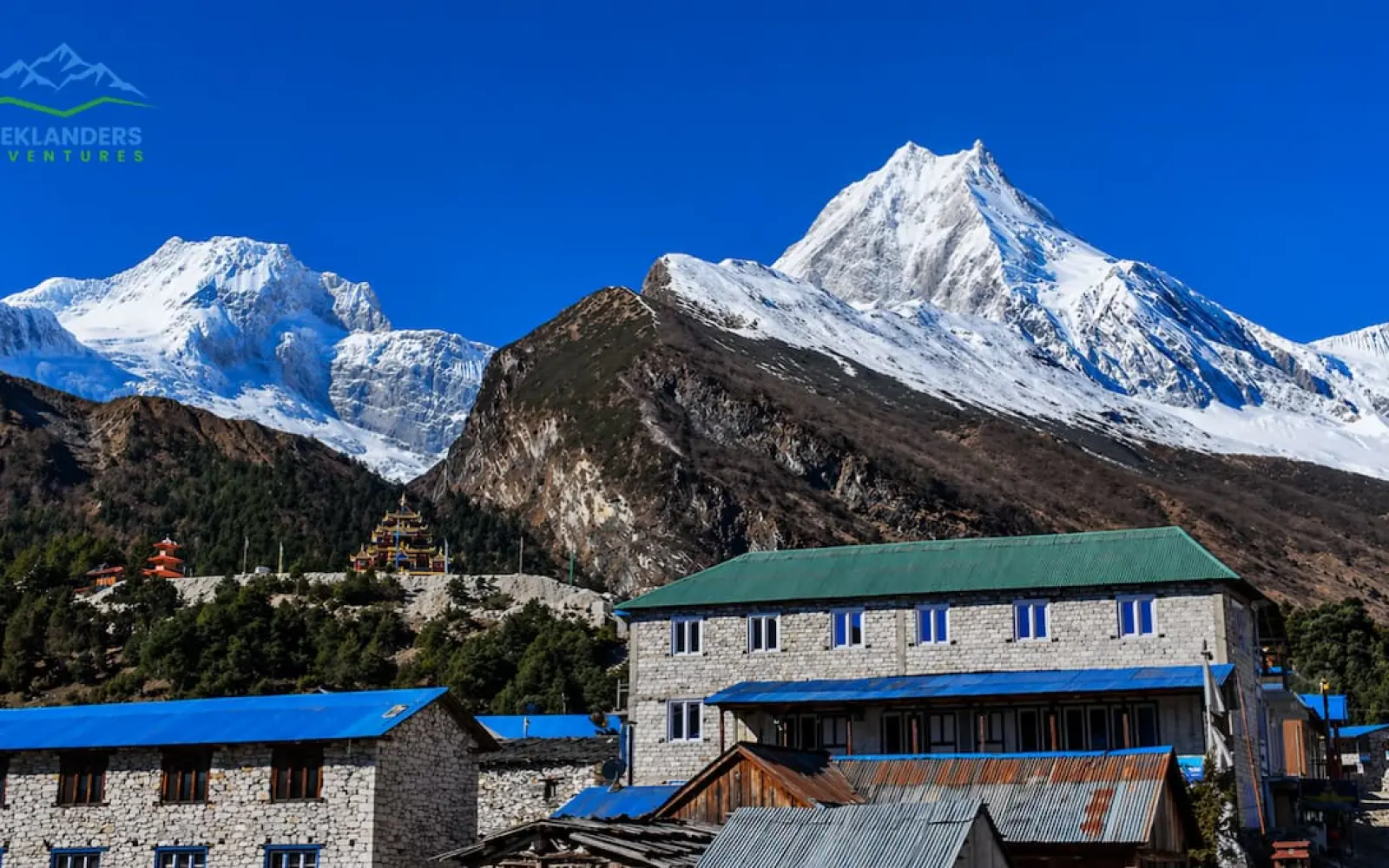
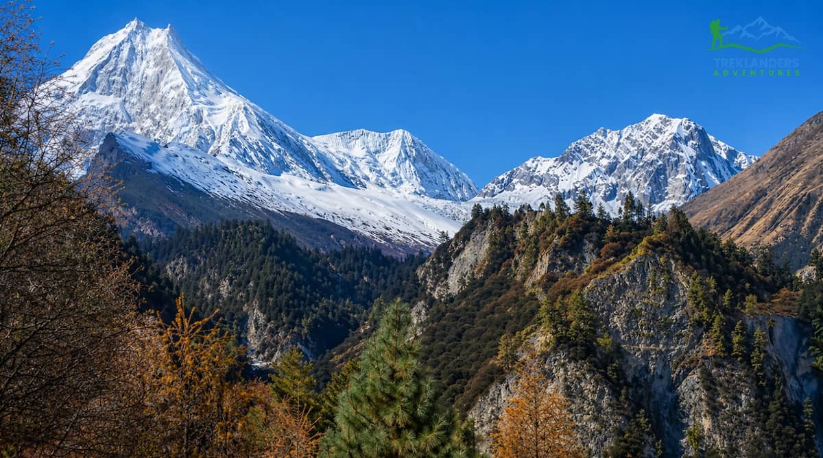
The Manaslu Circuit Trek is among the most amazing and yet the least visited Himalayan journeys in Nepal. Mount Manaslu, the eighth-highest peak in the world (8,163 m), dominates the route around which this remote trail is laid. The trek takes you over gorges, through rhododendron forests and Tibetan Buddhist cultural sites, and across high passes before reaching the Larkya La Pass (5,106 m), the symbol of the trek. Though October and November are still widely known as the best and only seasons for trekking in Nepal, more and more people looking for excitement are daring to ask: Might it be possible and even worthwhile to do the Manaslu Circuit Trek during the monsoon season?
The simple and direct answer is yes, if you come ready and equipped. The detailed and nuanced answer is what you will find here in this guide. With Treklanders Adventures, we have escorted many groups of trekkers to the region of Manaslu at different seasons. This detailed guide will be your source of information on monsoon trekking in the Manaslu Circuit. Here, you will see that we tell you what makes it difficult, what makes it attractive and worth seeing, the major risks you should be aware of, and the professional advice that can lead to a great and memorable Himalayan journey.
The monsoon season in Nepal generally lasts from late June to mid-September, with the heaviest rains usually happening in July and August. The monsoon halting from the Bay of Bengal makes a sweep across the Indian subcontinent, bringing heavy, almost continuous rains to large parts of the lower and middle elevations of Nepal.
That said, the monsoon's effect on the Manaslu Circuit is far more nuanced than just marking it as a 'wet season.' Manaslu valley lies in a kind of transition area between the southerly slopes of the Himalayas, which receive a lot of rain, and the drier Tibetan Plateau that is in the rain shadow of the mountains. What this means is:
Lower Manaslu Valley (Arughat to Deng): Receives heavy, frequent rainfall typical of the monsoon.
Mid-Valley (Deng to Samagaun): Gets moderate rainfall, with more frequent breaks in the weather.
Upper Valley and Larkya La (Samagaun and above): Often sits above or behind the main monsoon cloud layer, experiencing significantly less rainfall and sometimes remarkably clear, stable weather.
Because of this rain shadow effect, experienced hikers often choose the Manaslu Circuit as their destination for a monsoon climbing experience. As you ascend, the intense monsoon storms gradually disappear, and the dry, fresh air of the Himalayas takes over.
Why Consider Trekking Manaslu Circuit in Monsoon?
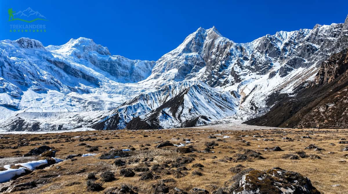
Trail along the Manaslu Circuit Trek
1. Far Fewer Trekkers
Apart from the monsoon season, the Manaslu Circuit route always has fewer trekkers than the Everest Base Camp or Annapurna Circuit routes. During the monsoon, the already quiet trail becomes almost deserted. If you wish to live an authentic, solitary Himalayan journey where it is possible to walk a whole day without encountering another trekking group, the monsoon is the right season for you.
2. The Nature Turns to a Dreamy Landscape
The monsoon turns the whole Manaslu scenery into an almost fairy tale one. The woods have become so dense and bright green that you cannot see through them. Waterfalls flow from every cliff and gorge, creating valleys where the sound and mist together form cathedrals that one can hear and perceive with one's own senses. Besides orchids and rhododendrons, there are other wildflowers which appear most abundantly. The terraced rice paddies in the lower valleys look like glowing jade of the most beautiful colour.
3. More Reasonable Prices and Greater Availability
Teahouses, guides, and porters are often more present, and their prices are usually lower during the monsoon. You probably will not have to plan at all for your stay, and more importantly, you will be more open to changing your planned schedule, as you will have good accommodation alternatives at any moment. Moreover, agencies offering the Manaslu Circuit trek professionally guided may drop prices during the low season, thus making this trekking option more affordable for budget-conscious trekkers.
4. Cultural immersion
There are fewer foreign trekkers on the trail. That way, the locals will be able to enjoy greater peace, and today, they are hanging out more openly with the foreigners. Monsoon is the time when many of the Manaslu valley's annual festivals and agricultural activities take place. So by going to the villages of Nubri and Tsum and observing their lifestyle, like the way they prepare fields, hold ceremonies, and take care of yak herds, one can have a truly meaningful experience of these communities that have not been heavily influenced by the trekking infrastructure.
5. The Upper Valley Rain Shadow
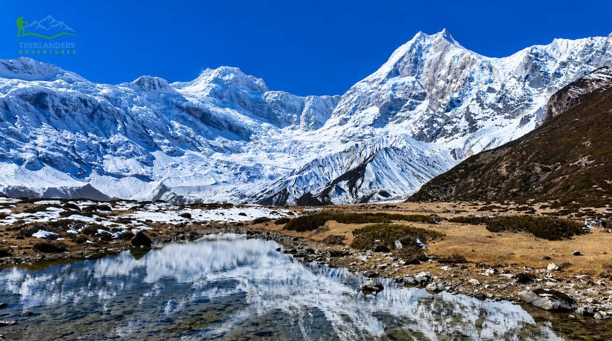
As already mentioned, the upper Manaslu valley and the vicinity of the Larkya La Pass are often in a rain shadow during the monsoon. Those who are seasoned in treks and can bear going through the lower valley's rains are likely to enjoy the benefits of the clean and dry environment of the higher elevations. The views of the mountains Manaslu, Himalchuli, and the Ganesh Himal range may be quite stunning in this zone during the monsoon.
The Real Risk: What You Most Understand Before You go
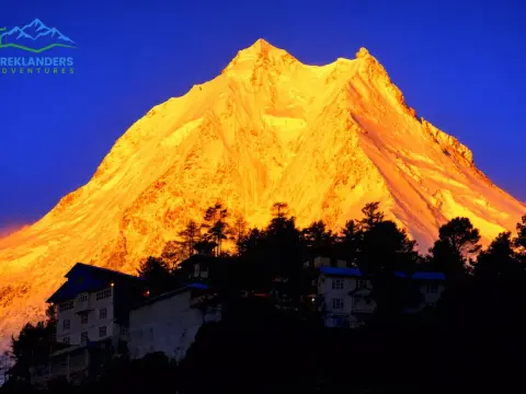
Breathtaking views of the Manaslu Range as seen from Pungen Gompa
Risk 1: Landslides and Rockfalls
This is hands down the greatest risk of monsoon trekking on the Manaslu Circuit. The lower Manaslu valley, especially the Buri Gandaki gorge between Jagat and Deng, is among the most geologically unstable areas of Nepal. Heavy monsoon rains lead to saturation of very steep slopes, dislodging of loose rocks, and set off landslides, which may destroy or block paths with little or no notice. Major danger spots are: The narrow gorge parts from Jagat to Ghap, the trails along the riverbank near Deng and Namrung, and any trail under a cliff covered with vegetation. Landslides on the Manaslu Circuit during monsoon have temporarily closed the trail for a few days or even weeks in some years, and there have been instances when trekkers were trapped by debris flows.
Risk 2: Flash Floods
The level of the Budi Gandaki River and its numerous tributaries sharply increases during heavy monsoon rains, sometimes rising several meters within a few hours. Trail parts that go along or cross the river become very risky. Suspension bridges, of which there are quite a few on the Manaslu Circuit, can be hit by floods or damaged, thus isolating entire parts of the trail. Even small side streams, which may seem insignificant in the dry season, can turn into wild and dangerous flowing torrents after heavy rains. There have been cases of trekkers who, after being caught in a flash flooding stream, were swept away and drowned on various Nepal trekking trails during the monsoon.
Risk 3: Trail Degradation and Navigation Challenges
Monsoon rains constantly wear away and deteriorate trail surfaces. Walkways turn into slippery mud. Wooden bridges decay or are washed away. River crossings that
Risk 4: Leeches
May not pose a direct threat to life, but leeches are a constant risk during monsoon trekking in the forest areas of Nepal. In fact, the Manaslu Circuit's lower forests between Arughat and Deng are notorious for leeches during the monsoon peak. In some areas, trekkers may be ambushed by dozens or hundreds of leeches in a single hour. Protective clothing, leech socks, and salt or leech repellent spray are must-haves for the trek.
Altitude sickness is a danger on the Manaslu Circuit all year round. However, during the monsoon, reduced visibility and bad trail conditions can not only hide the symptoms of altitude sickness but also make it harder to get a rescue. At 5,106 meters, the Larkya La Pass is the main high-altitude challenge, and helicopter lifts, already costly and sometimes hard to arrange in the Manaslu region, become even more difficult in monsoon weather.
Risk 6: Hypothermia and Exposure
When wet, cold conditions are paired with exertion and lack of proper shelter, it results in hypothermia. The upper Manaslu valley teahouses are less heated compared to those on the more commercialized routes, and the combination of the damp clothes, cold temperatures at high elevation, and wind chill can quickly make the situation dangerous if a trekker is under-equipped or needs rest.
Safety first
Landslides in the Buri Gandaki gorge remain the biggest single hazard.
Flash floods can happen on rivers, potentially submerging crossings and low trail sections.
Trails might be washed away, causing disruption and isolation for days or even weeks.
Affected by leeches are those who enter the lower forest zones (Arughat to Deng).
Altitude sickness may be worsened by monsoon weather and limited evacuation possibilities.
Hypothermia can result from wet and cold conditions at altitude.
Expert Tips for Trekking Manaslu Trek in Monsoon
Birendra Lake- Manaslu Circuit Trek
Tip 1: Hire a Knowledgeable Local Guide Mandatory to Manaslu Circuit
It is mandatory to have a licensed guide and a special restricted area permit while doing the Manaslu Circuit trek. Moreover, the importance of having a skilled local guide is increased by a factor of ten during the monsoon season. An excellent guide will be able to give you the latest information about trail conditions, they will know which river crossings are safe, they will be able to recognize early signs of landslides, and have connections with local communities that can provide places to stay, food, and information that no app or guidebook can supply. At Treklanders Adventures, our Manaslu guides are locals from the Manaslu and Gorkha regions and have the experience of doing this particular route in all types of conditions. Whenever there is a monsoon, we give each group a guide who has done the reconnaissance of the current conditions before the beginning of the trek.
Tip 2: Time Your Trek for Mid-Season Windows
The monsoon is not an unbroken downpour. The weather changes with systems, and experienced guides and meteorologists can identify multi-day periods of lesser rainfall or better conditions. Late June (before the monsoon reaches its full intensity) and mid to late September (when the monsoon recedes) are very good time periods. Sometimes, the second half of August also gives short periods of clearing. Do not get locked into a strict day-by-day schedule. Have some leeway in your trekking dates so that you can stay out of a heavy rainfall event in a safe and nice teahouse rather than going through dangerous, flooded trails.
Tip 3: Master Your Gear List for Wet Conditions
Monsoon trekking carries its own gear philosophy that differs from dry season trekking. The objective is not remaining dry a feat that is almost impossible but rather keeping warm, preserving your body temperature, and safe movement on wet ground.
Waterproof Trekking Boots: Essential. Make sure they are completely broken in before your hike. Carry gaiters.
Trekking Poles: The usage of trekking poles during monsoon season gains significantly more importance than any other season. They are practically indispensable on slippery and eroded paths.
Rain Jacket and Waterproof Pants: Don't settle for water resistant. Look for high quality, absolutely waterproof ones (such as Gore Tex or the like).
Quick Dry Base and Mid Layers: Merino wool or synthetic. Stay away from cotton at all costs it is quite dangerous in wet and cold conditions.
Dry Bags and Pack Cover: Make sure all your electronics, sleeping bag, and extra clothes are in dry bags inside your pack. Using a waterproof pack cover is another way of giving your gear extra protection.
Leech Socks and Repellent: Get yourself a dedicated pair of leech socks (these go over the regular socks and are then tucked under the trousers). Additionally, you will need a bottle of salt solution or commercial leech repellent. Continue reading for more tips.
Tip 4: Start Trekking Early Each Day
Generally, rain will be increasing during the day, and afternoons usually have the worst storms. So, try to start your trekking as early as you can, ideally around 6:00 or 7:00 AM, that way you can get to your teahouse before the worst rains come. This single action really minimizes your exposure to the dangerous conditions of the trail.
Tip 5: Know When to Stop and Wait
One of the biggest challenges when trekking during the monsoon is stopping at the right time. It may mean spending an unplanned rest day in a teahouse to wait for better trail conditions. Doing so is not a failure, but smart risk management. For example, if a river crossing today may be lethal, but after a couple of days of less rainfall, it could be safe. Similarly, if a landslide has blocked a trail section, it may be cleared by the workers within 24 to 48 hours. Before trekking, make a mental decision of 'turn back or wait' and inform your trekking partners about this concept. Remember, the mountains will still be there next year, but your safety is non-negotiable.
Tip 6: Stay Informed with Real-Time Trail Intelligence
Before your trek and when you reach each main stop on the trail, make it a habit of getting the latest information about the trail. Interview the trekkers who come from the opposite direction. Inquire the teahouse owners about the recent trail conditions, river levels, and landslide activities. Your guide should be linked with the local networks, so get the latest info from him/her. The Manaslu Conservation Area Project office can sometimes provide relevant safety information. At Treklanders Adventures, we maintain contact with our guides on the trail and with local teahouse owners throughout the season, allowing us to provide real-time updates to trekkers preparing to depart.
Tip 7: Insurance, Emergency Communication, and Evacuation Plans
Regardless of the time of year, having high-altitude trekking and helicopter evacuation insurance is a must when visiting the Manaslu Circuit, let alone during the monsoon season. Helicopter evacuation from the Manaslu area may cost between USD 3,000 and USD 8,000 or even higher, and poor weather during the monsoon can result in evacuation delays from 24 to 72 hours. A satellite communicator (Garmin in Reach or other) that does not depend on cellular coverage should be in your possession since there is no cellular coverage in most of the upper Manaslu valley. Make sure your guide has emergency contact numbers of CIWEC Clinic, the Himalayan Rescue Association, and Treklanders Adventures' 24-hour emergency line.
Tip 8: Acclimatize Conservatively, Even More So in Monsoon
Acclimatization hike to Pungen Gompa during the Manaslu Circuit Trek
The physical requirements of monsoon trekking, heavier, waterlogged gear, tricky terrain underfoot, and psychological stress due to poor weather imply that your body is working harder than if conditions were ideal. This, in turn, raises the chance of altitude sickness. Adhere to the 'climb high, sleep low' strategy and be stricter with it than usual. If a member of your group has acute mountain sickness symptoms, do not continue pushing to reach Larkya La Pass. The pass will still be available to you tomorrow.
You arrive in Nepal's capital city, from where you are taken to your hotel by vehicle. You may well want to use the day to prepare your equipment and have a good rest. Kathmandu is situated at a pretty moderate height, so you can probably forget about the problems of acclimatization for now. Besides, this is a great opportunity to check your permits, buy the last-minute things that you need, and go to bed quite early.
Day 2: Kathmandu to MachhaKhola (930m / 3,051ft) 8-9 hrs. drive.
You head off from Kathmandu at the crack of dawn. The driving itinerary goes along the Prithvi Highway heading west and then changing direction to the north, entering the Budhi Gandaki valley. Certain parts of the road may be quite bumpy, especially after Arughat. Don't be surprised by sharp bends, river crossings, and especially scenic views of terraced farmland. You will descend to below 1,000m, so the air will feel dense and warm. You will reach MachhaKhola only by late afternoon.
Day 3: MachhaKhola to Jagat (1,340m / 4,396ft) 6-7 hrs.
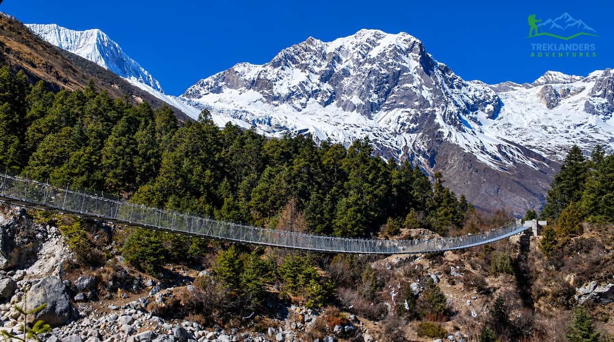
This is your first day entirely on foot. The pathway runs along the Budhi Gandaki River through a very narrow gorge covered by a dense subtropical forest. You will also visit quite a few small Gurung and Magar villages, cross several suspension bridges, and experience the gradual gain in height throughout the day. Since the landscape is quite soft, you can recognize this day as a good introduction day for your muscles.
Day 4: Jagat to Deng (1,860m / 6,102 ft) 6-7 hrs.
From Jagat, you officially enter the Manaslu Conservation Area, where the scenery changes as the valley narrows and the river gets more deeply cut. You can expect a checkpoint at Philim to ensure your Manaslu Restricted Area Permit. The path to Deng leads you through a mix of woods, fields, and stony stretches. Village lifestyles also change visibly here; Tibetan Buddhist presence grows more prominent.
Day 5: Deng to Lho Gaun (3,180m / 10,433ft) 6-7 hrs.
Elevation will be the main challenge on this day as you gain over 1,300m. You will hike along a rhododendron and oak forest trail and pass the village of Ghap before the wide, high-altitude valley at Lho appears. At Lho, Manaslu (8,163m), the eighth-highest mountain in Nepal, will be the first big thing you spot. Altitude is very different here; slow your pace and stay hydrated.
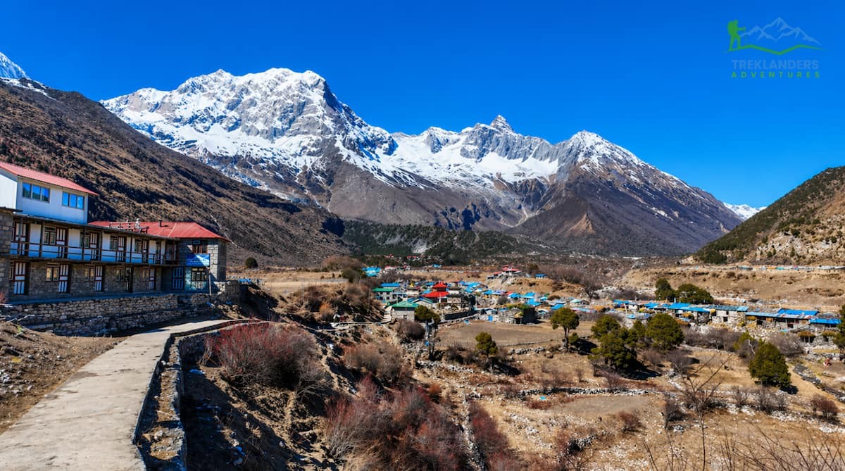
Day 6: Lho Gaun to Samagaun (3,530m / 11,581ft) 4-5 hrs.
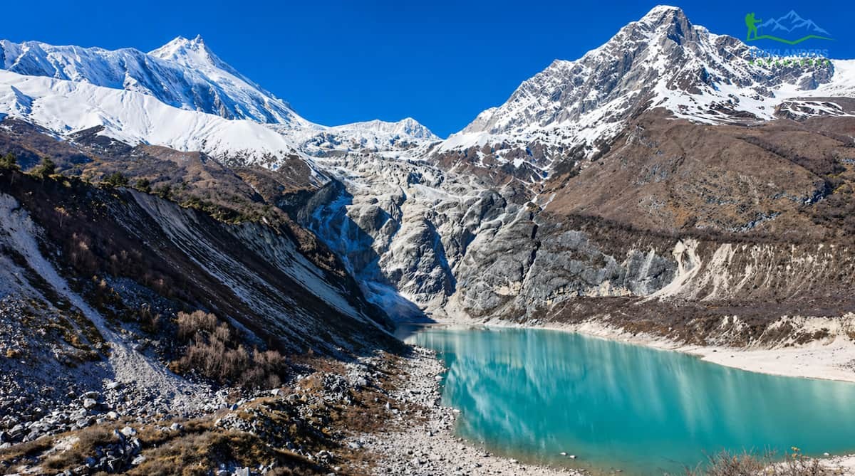
Samagaun- Manaslu Circuit Trek
Today is a rest of sorts for the body as it was quite exerted the previous day going to Lho. The path does not descend until you get to the Tibetan-style village of Samagaun, but it offers you sights of Manaslu and its adjoining peaks. You will be spending two nights here, so come early to unwind.
Day 7: Acclimatization Day in Samagaun (3,530m / 11,581ft).
Make sure you don't miss this day. When you are at 3,530m above sea level, your body needs some time to get used to the altitude before you can go up even higher. You can spend the day doing a little hike near Manaslu Base Camp (4,800m) or to the Birendra Tal glacial lake. Both are great options that will help you acclimate without causing you too much fatigue. Afterwards, come back to Samagaun for dinner and rest, as you will be staying at the same altitude.
Day 8: Samagaun to Samdo (3,875m / 12,713ft) 4-5 hrs.
This is going to be a day when you gradually go uphill most of the time. As you get closer to Samdo, which is a small trading village near the Tibetan border, the valley will be more open and barren. You will notice that the sunlight at such high altitudes is very bright and the air is quite thin. Samdo is the last significant place where people live before the pass. Make sure you eat a heavy meal tonight and keep hydrated.
Day 9: Samdo to Dharamsala (4,460m / 14,633ft) 4-5 hrs.’
Dharamsala are just a group of stone teahouses that form the base camp before the Larke La Pass, not a village. You will be climbing steadily on a trail that goes over moraine and rocky ground, with glaciers in the distance. Getting here early will give you plenty of time to eat, sleep, and get ready mentally for the coming challenge. The teahouses are quite simple. Nighttime temperatures will be quite low. Try to sleep as early as possible.
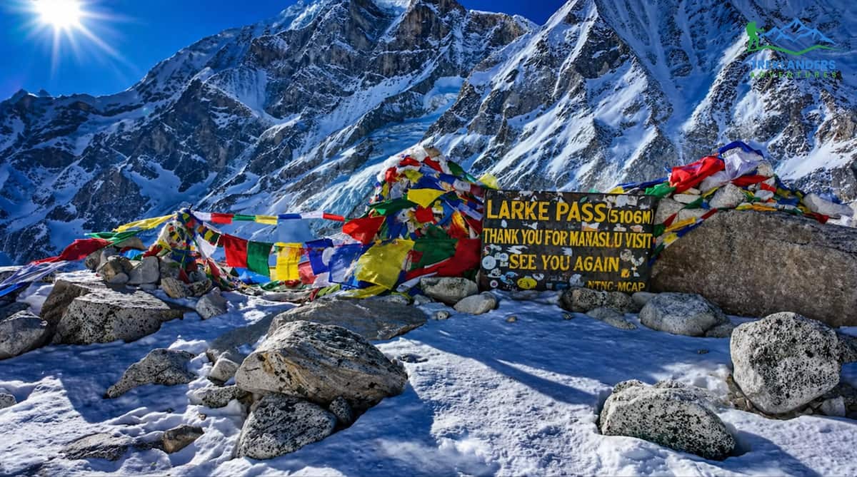
Day 10: Larke Pass (5,106m / 16,752ft) to Bhimthang (3,720m / 12,205ft), 8-9 hrs.
Larke Pass- Manaslu Circuit Trek
It is the toughest day of the trek. You need to start by 4:00 AM. The climb to the Larke Pass is quite challenging, icy, and the mountain is exposed throughout, with a few ropes fixed on the top section. The peak is at 5,106 m. If you get a clear day, the sights of Manaslu, Himlung, Cheo Himal, and the Annapurna range will be stunning. The way down to Bhimthang is really long and will hurt your knees, so better to move slowly. You will get to Bhimthang in the afternoon.
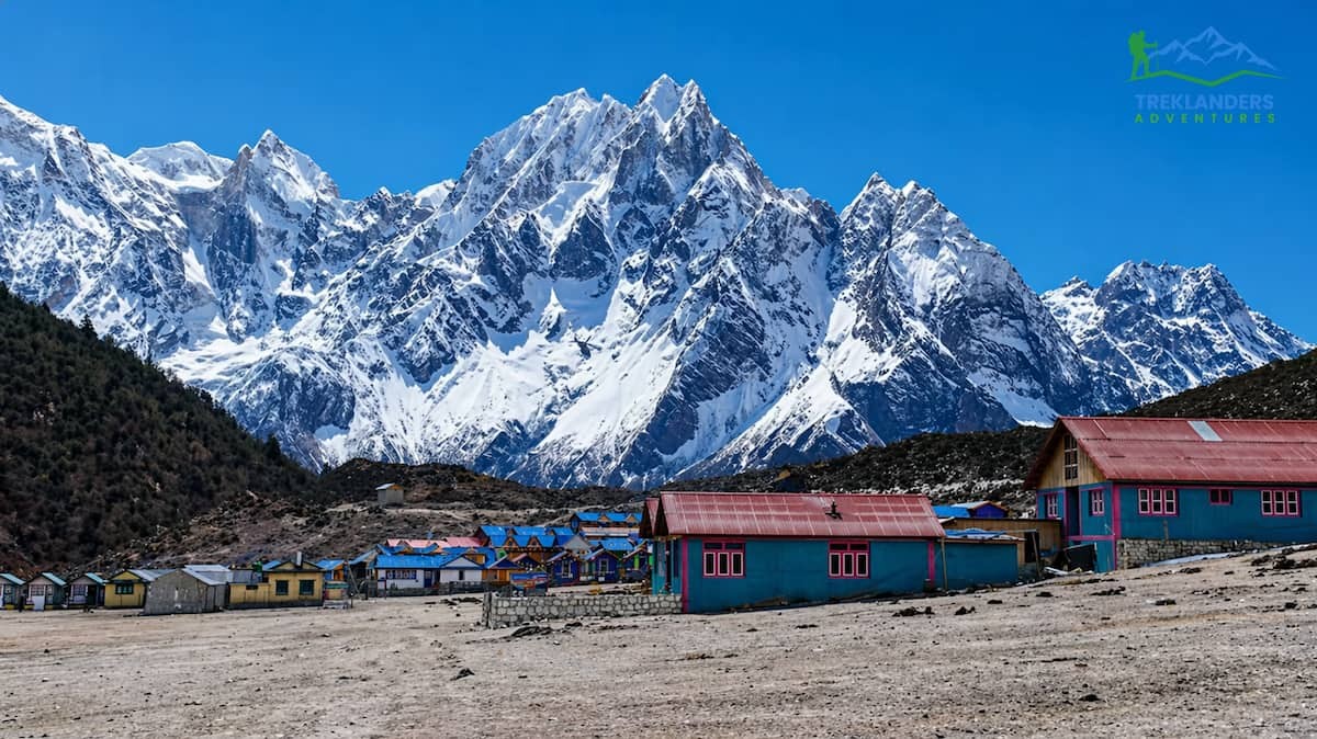
Day 11: Bhimthang to Tilije (2,300m / 7,546ft) 6-7 hrs.
Bhimthang- Manaslu Circuit Trek
The trail is going down further through rhododendron forests and alpine grassy meadows. Physically, you will feel better quickly when you breathe in the more humid and thicker air of the forest. Tilije is a tiny, serene village in the Dudh Khola valley with nice teahouses. You have gotten through the most difficult area of the trek; the rest of the trip is a slow walk back to civilization.
Day 12: Tilije to Dharapani (1,963m / 6,440ft) 3-4 hrs.’ walk, then drive to Besisahar (760m / 2,493ft) 4-5 hrs.
In the morning, you only need to walk a little to get to Dharapani, where the Manaslu Circuit and Annapurna Circuit trails come together. After that, you take a jeep going south to Besisahar. Driving down from there, one goes through the lower river valleys while stopping at various villages connected through one of the busiest highland roads in Nepal. Having spent nearly two weeks in the mountains, Besisahar will seem like a town to you.
Day 13: Journey from Besisahar to Kathmandu (1,365m / 4,478ft), 6-7 hrs. driving.
A tiring road trip, but you will be very comfortable in the car. Moving south, the road is getting better all the way to Kathmandu. You can use the time to the end to get some rest, daydream, or, if you are a planner, think about the things you want to do on your last night in the city. You should reach Kathmandu no later than mid-afternoon. This is your very final night in Nepal.
Day 14: The trip to the airport
Tribhuvan International Airport is the location where your transfer will leave you. Often, airlines require passengers to check in at least 3 hours before international departures.
Permits Required
There are three permits needed for the Manaslu Circuit. The Manaslu Restricted Area Permit (RAP) is the main legal document, allowing you to enter the restricted area along the path. The Manaslu Conservation Area Permit (MCAP) is for your travel through the conservation area, and the Annapurna Conservation Area Permit (ACAP) is necessary if you exit via Dharapani to Besisahar. You get all three in Kathmandu from the Nepal Tourism Board or a registered trekking agency before leaving.
Monsoon Regulations
Manaslu circuit forbids solo trekking throughout the year, including monsoon time. You have to trek at least with a guide who is registered. Most walkers get a porter as well, which is highly recommended because of the wet and slippery trails and also carrying a heavier pack with rain gear. Since the area is restricted, your permit will be checked at many army and police points along the route, mainly at Jagat and Samagaun. Have printed originals of your permits with you all the time. Remote checkpoints won't accept the digital versions. Monsoon trekking turns up the danger level due to landslides and trail washouts. Many local bodies temporarily close trails after heavy rains. Your guide watches over these conditions and is the one making decisions about the route. Think about it in your timetable and don't stick to your itinerary too rigidly.
Monsoon vs. Peak Season: Side-by-Side Comparison
Factor
Monsoon (June–Sept) vs. Peak Season (Oct–Nov)
Trail Crowds
Monsoon: Very few trekkers | Peak: Moderate (busier than Everest/Annapurna)
Monsoon: Open, uncrowded, flexible | Peak: Open, more crowded
Wildlife
Monsoon: Birds active, lush flora | Peak: Some wildlife migration
Cost
Monsoon: Lower (guides, porters, lodges more available) | Peak: Standard pricing
Difficulty
Monsoon: Higher (terrain, weather) | Peak: Standard
Leeches
Monsoon: Heavy in lower zone | Peak: None
Teahouses and Accommodation During Monsoon
Teahouses and accommodation in Bimthang during the Manaslu Circuit Trek
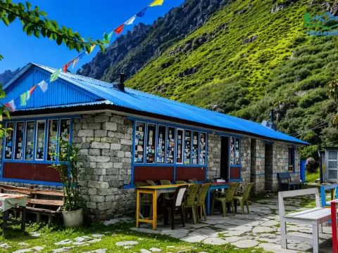
The Manaslu Circuit has a very good network of teahouses all over the trail. You can stay at a teahouse in every village along the way, from MachhaKhola up to Bhimthang. Most teahouses will remain open during the monsoon, but there will be significant differences in standards, especially as you go higher and further into the wilderness. Those teahouses in the lower parts of the valleys near Jagat and Deng are quite well off, having private rooms, bathrooms attached to rooms, and decent food menus. The closer you get to the crest, from Lho Gaun and upwards, the fewer facilities you will find. There will be shared squat toilets, mattresses will be thin, and hot water will be limited.
Since the monsoon is when fewer tourists come, it can be a great advantage for you. In most cases, you will not have to fight for a bed at all, and the hosts of teahouses will often be more than happy to take care of you because they have fewer guests to look after. On the other hand, keep in mind that it would be unreasonable to expect the level of service that you would have gotten in the October peak season. Because supply runs may be hindered by the roads getting washed out, some of the smaller teahouses stop serving the full kitchen menu during the monsoon.
In fact, even at the highest altitude, heating is only very little. Make sure you have a sleeping bag with you that can withstand a temperature as low as- 10 degrees Celsius. The dampness here will make the lodges feel even colder than what the thermometer shows. Try to dry your clothes every morning so that they do not get wet in the daily rain, which usually shows up in the early afternoon. As for Dharamsala, which is the camp before the pass, it features the most basic accommodation, which includes stone huts with wooden bunks. Get there before the others to get a bunk and make yourself comfortable, since the temperature falls quite a lot after sunset.
20 Day Manaslu Circuit with Tsum Valley Trek | 20 days
Acute Mountain Sickness (AMS), High Altitude Pulmonary Edema (HAPE), and High-Altitude Cerebral Edema (HACE) are real risks on the Manaslu Circuit. The Larkya La Pass at 5,106 meters is the crux high-altitude point. The standard acclimatization rest day in Samagaun (3,530 m) is mandatory, not optional. Trekkers should be familiar with the symptoms of AMS and carry Diamox (acetazolamide) as a preventative measure if recommended by their physician.
Waterborne Illness
Monsoon increases the risk of water contamination. All drinking water must be treated with boiling, purification tablets, or a quality filter such as Sawyer Squeeze or SteriPen UV. Do not rely on teahouse water without treatment. Gastrointestinal illness can rapidly deplete energy and accelerate dehydration, both serious issues at altitude.
Skin and Foot Care
Extended wet conditions are hard on skin and feet. Trench foot tissue damage from prolonged wet and cold exposure is a risk on multi-day monsoon treks. Change socks whenever possible, use moisture-wicking materials, apply anti-fungal foot powder, and dry your feet thoroughly each evening. Check for blisters and cuts daily; any wound in a humid, bacteria-rich monsoon environment can become infected quickly.
Leech Bites
Leech bites are not medically dangerous for most people, but they can become infected if not treated properly. Do not pull leeches off. Use salt, a lit match, or leech-specific repellent to encourage detachment. Clean all bites with an antiseptic and monitor for signs of secondary infection over the following days.
Mental Health and Monsoon Fatigue
This is rarely discussed but genuinely important. Multiple consecutive days of rain, grey skies, limited views, difficult trail conditions, and mud can erode mental resilience. Experienced monsoon trekkers often report that psychological preparation, setting realistic expectations, cultivating mindfulness about the present experience rather than fixating on clear-sky views, is as important as physical preparation.
Conclusion
Beautiful mountain views from Lho Village during the Manaslu Circuit Trek
The Monsoon Manaslu circuit is not a piece of cake for the majority of people. Along this path, you are required to have more experience, better judgment skills, a larger adaptability range, and a higher level of endurance for discomfort as compared to the same trip done in October or November. The dangers are quite real and should be acknowledged, not underestimated. Nevertheless, for those who are well prepared, aware, and willing to take risks, the Manaslu monsoon trek provides a truly unique experience in today's world of heavily trafficked Himalayan trails: solitude, wilderness, and a meeting with the mountains in their most raw and primal state. The thunderous rivers, the mist-covered steep valleys, the superbly green woods, the silent hamlets where you are frequently the only foreigner, the stunning performance of tempest clouds surrounded by 8,000-meter peaks, these are the moments that no autumn trek, no matter how delightful and clear its skies, can reproduce.
At Treklanders Adventures, we consider the monsoon Manaslu Circuit, if done properly, to be one of the most meaningful trekking experiences in the Himalayas. Also, we think that 'doing it right' implies doing it safely, responsibly, and with a profound respect for the puissance of the mountains and the monsoon that adorn them each summer. In case you are willing to visit the Manaslu Circuit during the monsoon season, or if you are thinking of talking to us to decide whether it is the right choice considering your level of hiking experience and risk-taking willingness, our crew is at your disposal. Contact Treklanders Adventures, and together we will assist you in your planning for the journey of a lifetime in the mountains.