
Dingboche vs Pheriche for Everest Base Camp Trek: Which Acclimatization Stop is Better?
30 May 2026
Dingboche vs Pheriche: Which acclimatization stop is better for a safer and more successful Everest Base Camp Trek?
One of the most popular trekking routes in Nepal is the Annapurna Circuit. The route will lead you through dense jungles, cold, dry areas, local Buddhist communities, and a mountain pass where you will be higher than most of the world's peaks. That is already a big physical and mental challenge for most walkers.
However, if you add Tilicho Lake, a small break from the main route which brings you to the world's highest glacial lake at 4,919 meters, then you are talking about a trek which can be carried out at two completely different levels of difficulty. Both of these top spots, Tilicho Lake and Thorong-La Pass, are what shape the full Annapurna Circuit. They each pose a challenge differently. You will need different physical and mental strength for each of them. And together they transform a wonderful trek into one of the most memorable high-altitude journeys in the Himalayas.
This document presents side-by-side pictures showing what is different about each difficulty on its own, how those two difficulties affect each other when you bring them together on a single 15-day itinerary, and what is important for you to complete the whole circuit with Treklanders.
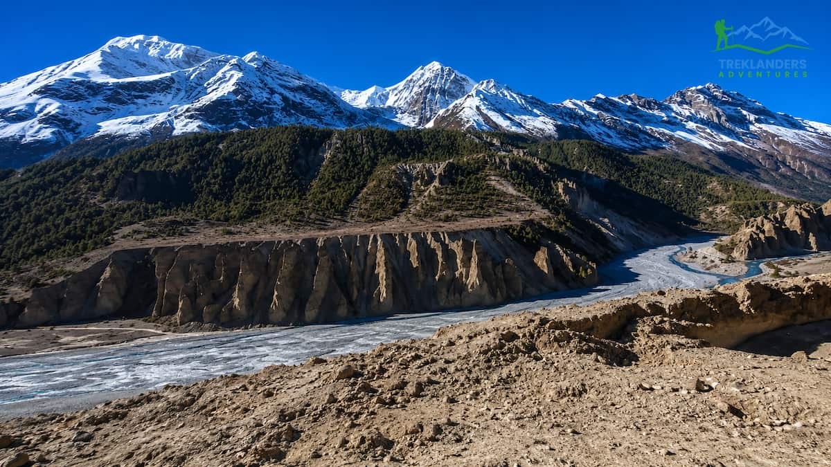
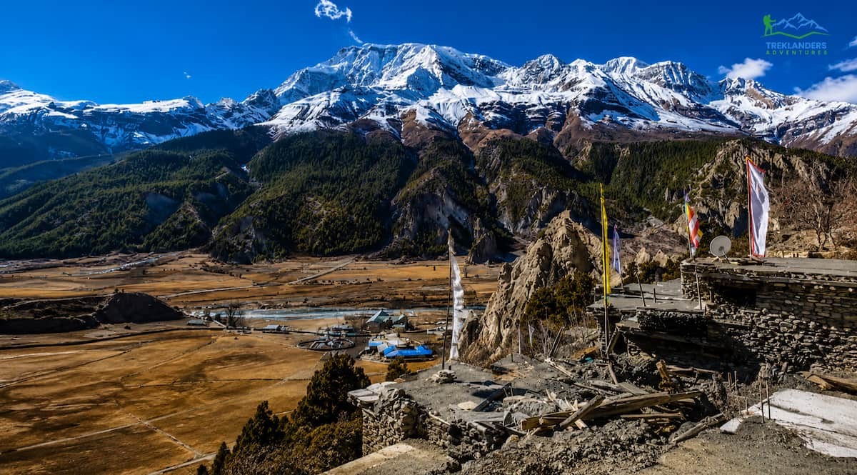
Moving upstream along the Marsyangdi River, the Annapurna Circuit starts at Besisahar in Lamjung district's foothills and gradually climbs through pine forests, apple orchards, and Gurung villages before arriving at the high valleys of Manang. After Manang, the classic Annapurna Circuit goes over Thorong-La Pass (5,416 m) and descends into the Mustang district, terminating at Jomsom, which is situated on the ancient Trans-Himalayan salt trade route between Nepal and Tibet.
Treklanders Adventures offers a complete circuit of about 15 days covering this whole arc with an important detour to Tilicho Lake. The itinerary is: Kathmandu to Besisahar, then to Dharapani, Chame, Pisang, Manang, Khangsar, Tilicho Base Camp, Tilicho Lake, Shiri Kharka, Yak Kharka, High Camp, Thorong-La Pass, Muktinath, Jomsom, Pokhara, and finally back to Kathmandu.
In fact, you're doing a moderate-to-adventurous trek. For one, you're stepping on the two highest points of any trekking route in Nepal. Secondly, you're walking on steep, rocky tracks that are above 4,000 meters. Besides this, you'll be crossing various climate zones on one single trip.
The maximum altitude you attain is 5,416 meters at Thorong-La Pass. The second major altitude landmark is Tilicho Lake at 4,919 meters. Both places need proper acclimatization, paced ascent, and physical training. However, they pose their challenges in quite different ways.
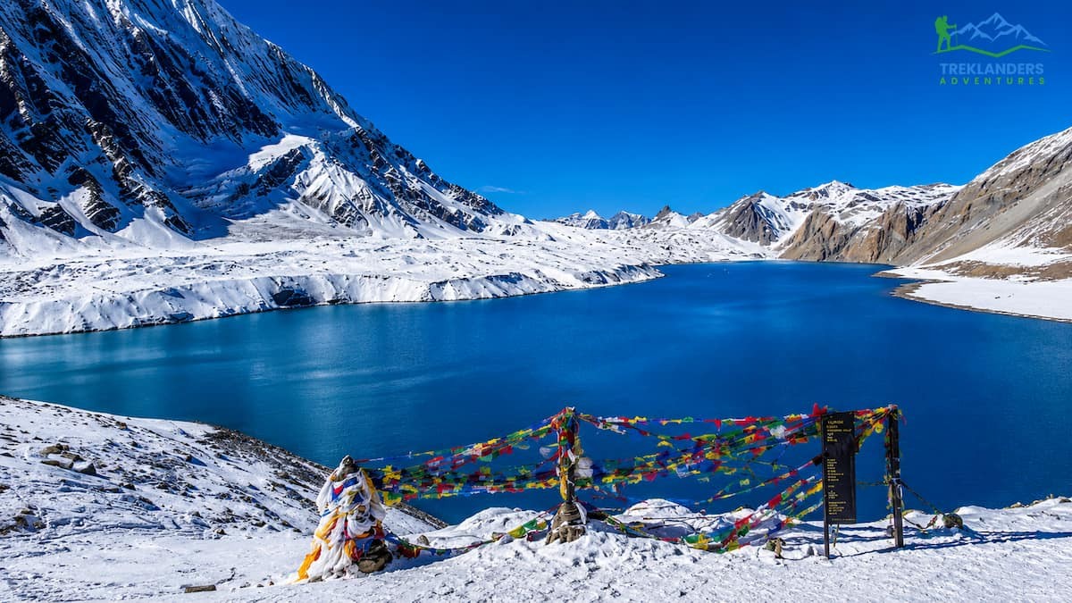
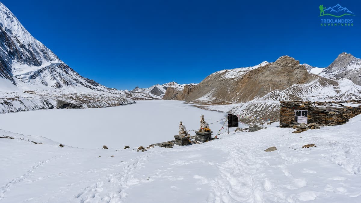
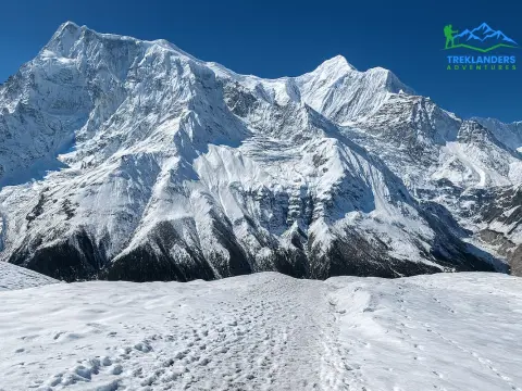
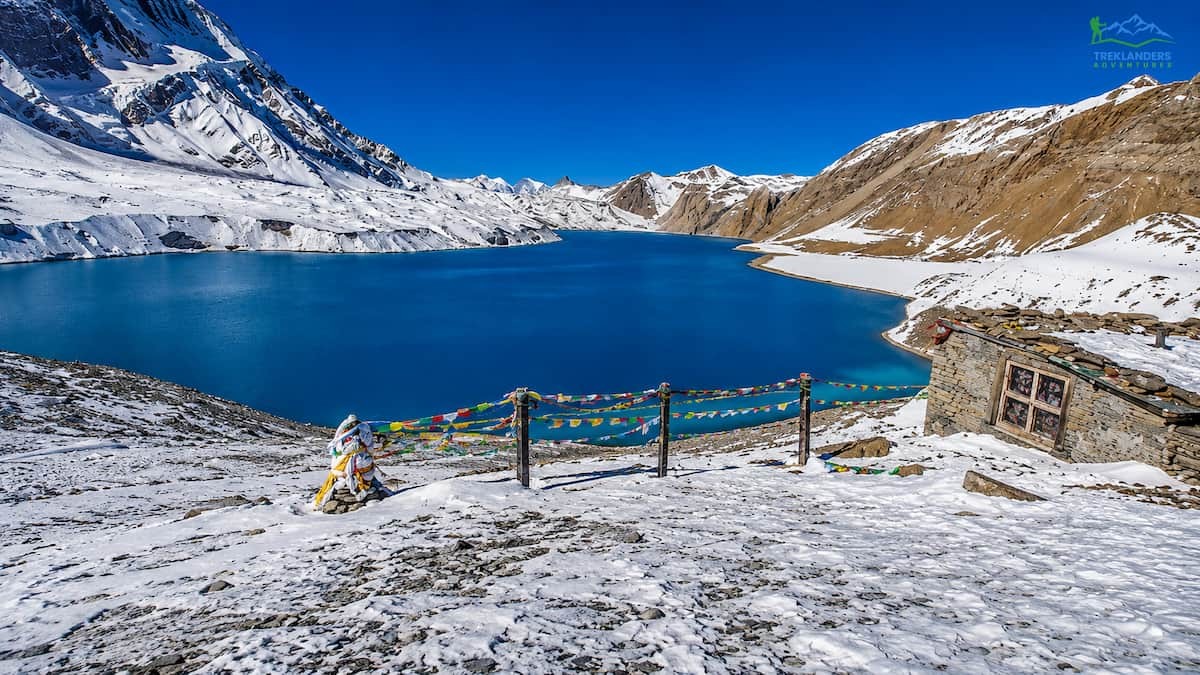
Tilicho Lake is located at an altitude of 4,919 meters in the Manang district of Nepal's North Mid-West region. It is awarded as the highest glacial lake on the planet, a title that attracts trekkers who want to combine high mountain passes with other adventures. The lake is a beautiful turquoise color and is sharply contrasted with the dry, rocky environment around it. Tilicho Peak, Gangapurna Himal, and the Nilgiri massif are some of the mountains that encircle it.
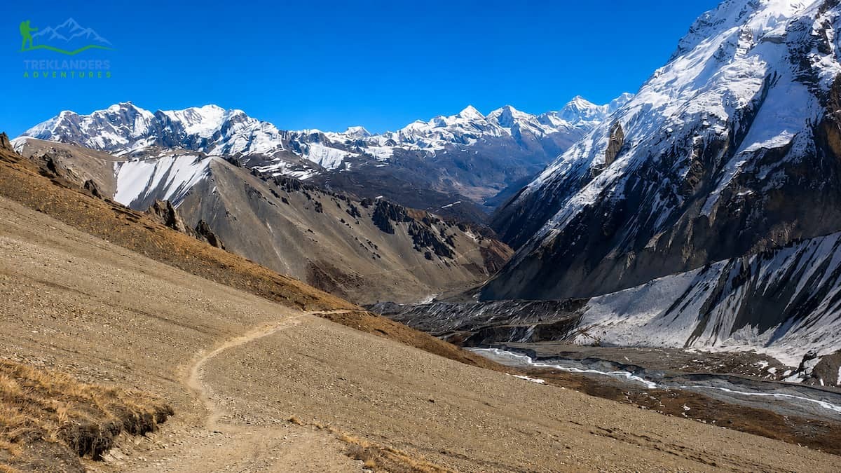
Getting to Tilicho Lake involves departing from the main Annapurna Circuit trail at Manang village. After this, the way progresses towards the west via Khangsar village, elevation 3,734 meters, before going up very steeply to Tilicho Base Camp at 4150 meters. The following day, trekkers continue even further to the lake itself.
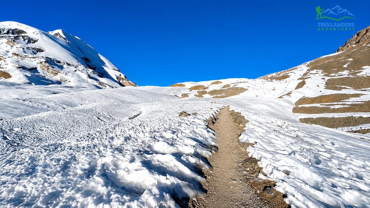
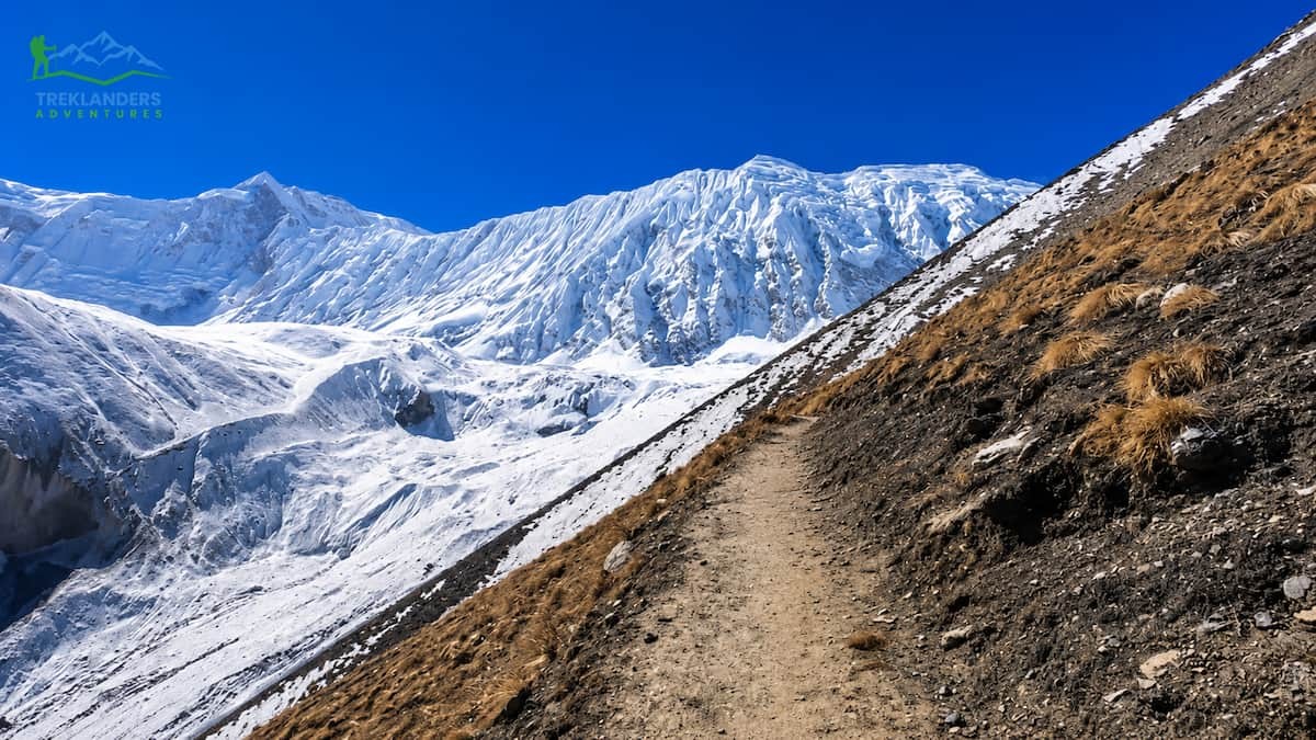
The route from Tilicho Base Camp to the Tilicho lake runs along a ridge with rocky terrain and scree slopes. The climb is quite exposed. Some parts of the trail require extremely careful steps on the narrow paths located above the sheer drop areas. The route is not technical in a climbing sense, but it does require excellent balance, calmness, and a slow, very deliberate pace.
The fact that elevation and terrain are combined makes Tilicho Lake exceptionally challenging. You will have been traveling at high altitude for several days before arriving at the base camp. Going to the lake means that you will have to climb another 769 meters from the base camp single-handedly in the morning. At high altitude, even a slight increase in slope can become a major challenge. Your lungs will have to work harder. Your legs will get tired at a much faster rate. The wind along the exposed ridgeline can be quite strong.
After arriving at the lake and soaking up the atmosphere at this phenomenal place, the trail goes back to Shiri Kharka past Tilicho Base Camp. So, your day is essentially a very long out-and-back with major ups and downs. Overall, you should plan for walking six hours plus stopping time.
The remoteness of this part not only makes it more challenging but also adds to its charm, I guess. After departing Manang, you will slowly see less and less infrastructure. Khangsar is a very last permanent village. At Tilicho Base Camp, there is a small collection of lodges. At this altitude and remoteness, it generally feels like a genuine wilderness experience.
Actually, at the lake, hikers sometimes linger for so long they become part of the scenery. The turquoise water framed by the rock and snow makes for a beautiful picture. Silence is outright on calm mornings. To add to the ambience are the close views of Tilicho Peak, Gangapurna Himal, and Nilgiri. Most hikers who do this stretch call it the most visually stunning moment on the whole circle, totally different in character from the pass crossing several days later.
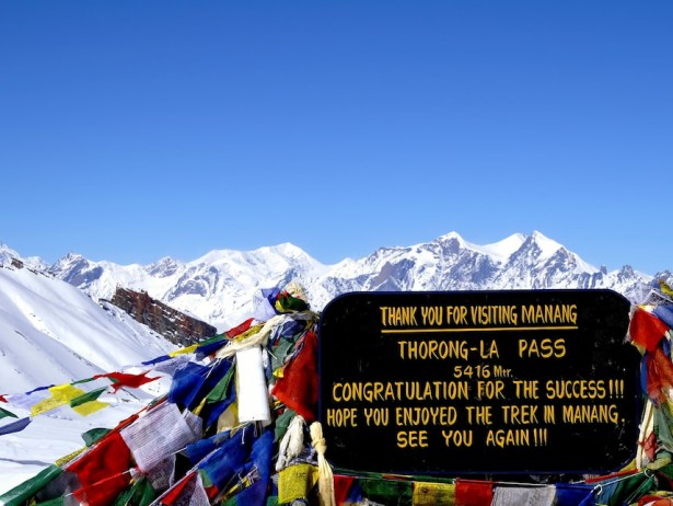
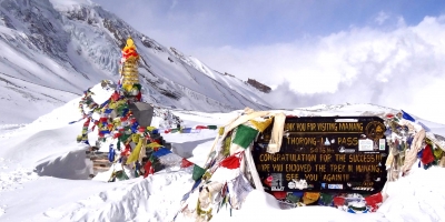
At 5,416 meters, the Thorong-La Pass is the highest point of the Annapurna Circuit, and it also serves as the boundary line between the districts of Manang and Mustang. Indeed, the moment when one crosses the pass is the defining highlight of the circuit. For most trekkers, it represents the most grueling single day of their entire journey.
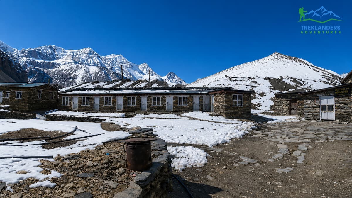
Generally, the crossing is initiated at 4:00 or 5:00 in the morning from High Camp, which is located at 4,900 meters. Getting up early is a must. Winds on the pass suddenly pick up, and the cold becomes more severe by mid-morning. If you start before dawn, you will have the best chances of going up to the summit before the weather gets worse.
After leaving High Camp, the path gradually goes through exposed, windswept areas. The incline by itself is not very steep, but due to the thin air, every 100 meters of altitude gain seems quite a lot. The way curls upwards through heaps of rocks and frozen soil. When you are just about to reach the pass, the climb becomes more difficult, and you can really feel the lack of oxygen.
When you are at 5,416 meters, the oxygen level is about 50% of what one inhales at sea level. Thus, even really healthy and acclimatized trekkers will find themselves short of breath, slow, and fatigued. Many also get headaches. The cold, particularly when you take into account the wind chill factor, can be very severe even during spring and autumn. The temperatures at the pass often fall to sub-zero levels in the early morning.
Walking down to Muktinath involves a drop of around 1,600 meters, which will take you several hours. While climbing is definitely tough, the descent that takes many more hours can be even harder on your legs and knees; in fact, most trekkers are surprised by it. When you eventually get to Muktinath at 3,800 meters, the whole walking day from High Camp will probably last for about seven hours or even longer.
From Thorong-La Pass, the view is very wide. If the morning is clear, you will be able to see Damodar Himal, Dhaulagiri, Chulu peaks, and a large part of the Annapurna range stretching in different directions. Standing on the pass after the hard climb and being surrounded by this huge panorama is one of the greatest moments of a Himalayan trek.
The summit prayer flags not only visually delineate the highest point of the circuit but also serve as a symbolic gesture. A diverse range of trekkers from many countries come here each season, have their photos taken, are out of breath, and have their fingers getting numb in their gloves. Fall starts almost at once because staying too long in the cold wind at 5,416 meters is very uncomfortable. However, the descent itself, which goes down through the air that is gradually getting fresher towards the holy place of Muktinath, is a physical and emotional unburdening from the intensity of the crossing.
Muktinath at 3,800 meters is holy for both Hindus and Buddhists. This pilgrimage site is renowned worldwide for the temple here, which features 108 waterspouts and a flame that is said to never go out. The temple court and its surroundings, where a fire burns perpetually, have been attracting devotees for a very long time. Getting there as the circuit passes through, the feeling of going from the wild and raw mountain setting to the calming and spiritual one of Muktinath is a shift that sticks in one's memory most of the time.
If you pair up Tilicho Lake and Thorong-La Pass in a 15-day circuit, you are challenging your body to two extreme high-altitude efforts only a few days apart from each other. Knowing how these two challenges affect you is very important for getting ready.
The Tilicho Lake side trip takes place first and starts from Manang on Day 7 of the Treklanders itinerary. You first hike to Khangsar, then proceed to Tilicho Base Camp, the next morning, summit to the lake and descend again to Shiri Kharka. These tasks are spread across three days. After the lake, you merge back with the main circuit path at Yak Kharka for the ascent towards Thorong-La.
This is the main revelation: the Tilicho part serves both as a physical challenge and an acclimatization method. Exposure of your body to 4, 919 meters by the lake and then a descent will lead to your body attaining altitude adaptation, which is very useful before the Thorong-La crossing. This is indeed in line with the most important principle of high-altitude trekking: climb high, sleep low. You first take yourself to the elevation, then withdraw to a lower sleeping altitude so that the adaptation can be consolidated.

The rest day at Manang on Day 6 is also an important component in the preparation for the demanding days ahead. Treklanders purposely schedule this acclimatization day in the itinerary to get the walkers used to higher altitudes. According to the program, there is also a brief walk to the points above Manang during the rest day, which will provide an active acclimatization opportunity for the trekkers rather than a passive one.
The net effect of this arrangement is that by the time you reach High Camp before Thorong-La, your body has already spent several days above 4,000 meters, visited a point close to 5,000 meters, and recovered back down. This preparation greatly enhances your safety and comfort in crossing the pass.
Altitude sickness is a genuine problem at both Tilicho Lake and Thorong-La Pass since they are located at high altitudes. Acute Mountain Sickness (AMS) is capable of getting anyone, regardless of how fit a person is. This sickness comes about through the process of going up one's altitude so fast that the body does not have enough time to get used to reduced oxygen levels.
The common signs of AMS are headache, nausea, loss of balance, decreased appetite, tiredness, and insomnia. The more severe ones are High Altitude Pulmonary Edema (HAPE) and High Altitude Cerebral Edema (HACE), which require urgent medical attention.
The 15-day Tilicho Base Camp with Thorong-La Pass Trek itinerary by Treklanders is planned to reduce the risk of AMS. The route climb is very gradual, and there are also quite a few short walking days in the upper Manang Valley. The acclimatization rest day at Manang is a well-thought-out measure to allow the body time to adapt before the Tilicho and Thorong-La compartments.
Besides this, trekkers need to equip themselves with enough understanding of the symptoms of AMS and be willing to make a descent immediately in case of serious symptoms. The main rule is a very strict one: if symptoms are getting worse, then descend. You do not need to risk your health for a summit, a lake, or a pass. Apart from that, the guides from Treklanders have been trained in altitude awareness and health monitoring. They observe the condition of the trekkers each day and can also give advice on when to slow down or turn back.
Hydration is one of your best protections. Ideally, trekkers at altitude will be drinking three to four liters of water every day. Drinking alcohol should be avoided for a few days before and during the high-altitude parts of the trip, as it will not only slow down the process of getting used to the altitude (acclimatization) but also affect the quality of sleep.
Some trekkers bring Acetazolamide (Diamox) along their journey with the purpose of preventing altitude sickness. However, before doing this, it is important to seek advice from your doctor since this drug has contraindications, and side effects include increased urination and tingling of the extremities. Aside from being merely a 'warming up' for the body and helping it adjust sooner; Diamox is not a substitute for proper acclimatization. The best approach is still a slow and gradual ascent with sufficient rest days.
Understanding what AMS feels like is very important. If one has a headache that hangs stubbornly even after hydrating and resting, bouts of nausea and tiredness when going above 3,000 meters, these are signs that should not be ignored. The moment symptoms are felt; trekkers should inform their guide. The Treklanders' guide team stays on top of the health of their group at all times and would not push a sick person to continue against their conscience. If a trekker has to go down, the team arranges a safe way out. At the most secluded spots of the circuit, the evacuation procedure encompasses emergency helicopter service. Because of this, having good travel insurance that covers helicopter rescue is not only a wise decision but also a requirement for all Treklanders bookings.
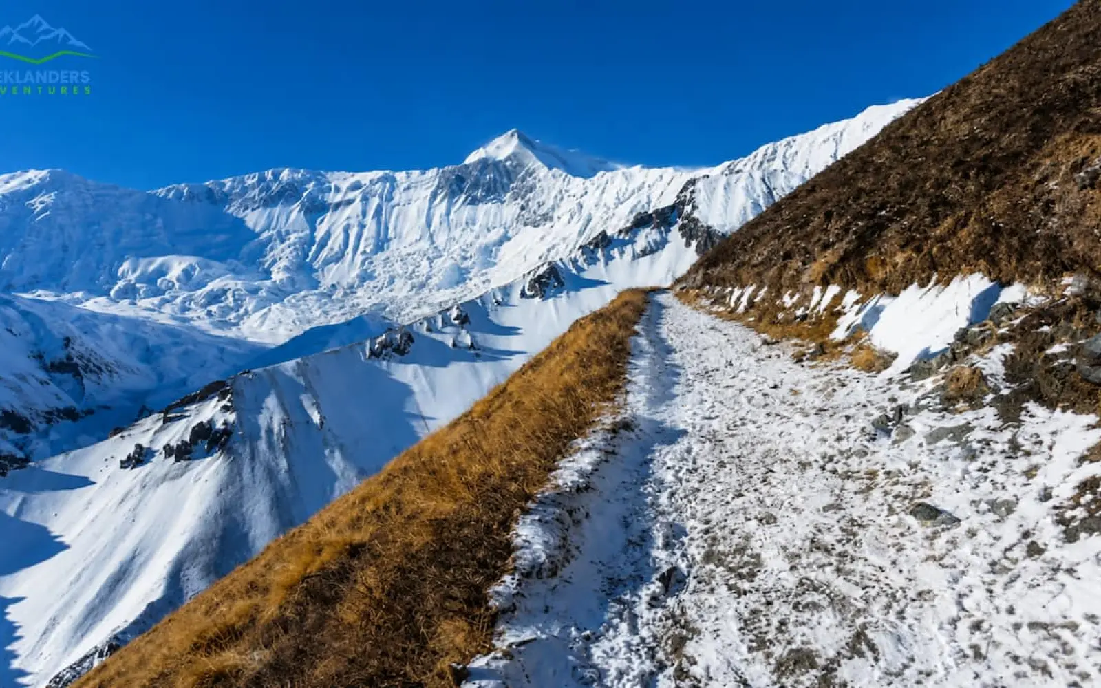
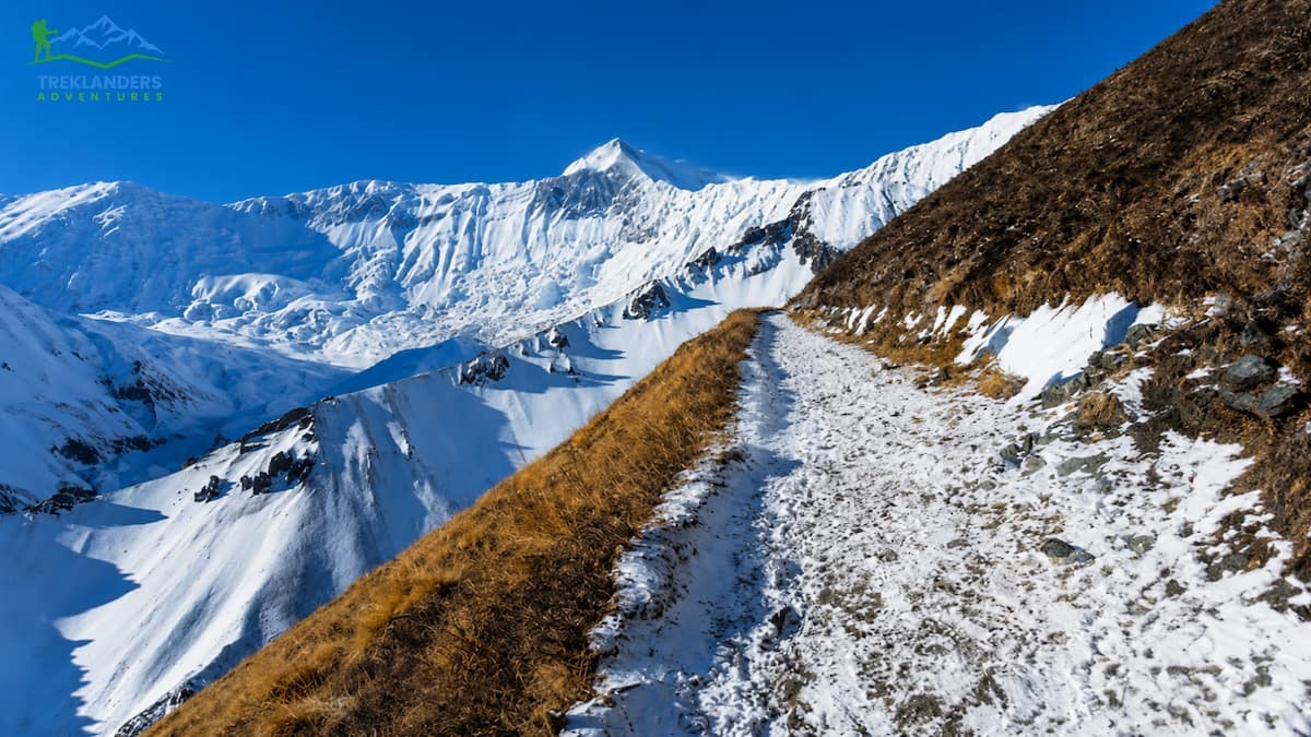
The physical nature of the trail varies a lot as you go on the circuit. In fact, the lower sections beneath Chame go through the forest on well-maintained paths. However, from Chame to Manang the trail is through a wide valley with dry terrain, and the wind is increasing.
Higher up, Manang, the trail is more difficult. The route to Tilicho Lake comprises scree slopes, exposed ridgelines, and steep rocky sections where you have to be really careful with your steps. Here, good trekking boots with ankle support and a firm grip are a must rather than an option.
The path from Yak Kharka to High Camp and then over Thorong-La is also rocky and exposed. In the fall, early snowfall is a possibility, which would make the pass icy and difficult to get across. In the spring, snow falling in the afternoon is also possible. The reason for starting very early in the morning for the pass crossing is to some extent that people want to get to the top before the weather changes for the worse.
Going down from Thorong-La to Muktinath is over very steep, loose ground. After just a few hours of walking uphill, this descent really puts the knees and quadriceps to the test. Trekking poles come highly recommended for both the Tilicho Lake approach and the Thorong-La crossing. Besides lightening the load on the joints, they also help with balance on uneven ground.
Packing the right footwear is not negotiable. Trail runners are adequate for the lower circuit sections, but above 3,500 meters, waterproof trekking boots with proper ankle support make a genuine difference. The rocky, uneven path near Tilicho Base Camp and the potentially icy surface near Thorong-La both call for boots with firm soles and reliable grip. Break in any new boots before the trip. Blisters at 4,500 meters are a serious inconvenience that can slow your entire group.
Treklanders' description classifies this as a moderate-to-adventurous level trek. The assessment will be quite valid if the trekkers butcher the trail after proper preparation. However, it may be extremely challenging for anyone who comes untrained.
This circuit consists of trekking for five to seven hours on average per trekking day. On a few days, the duration is more than six hours, especially when the detour to Tilicho Lake and the crossing of Thorong-La are involved. The combined toll of daily walking for two weeks, along with altitude, is what actually makes the trek physically demanding.
Preparation should ideally start six to eight weeks before the departure date. Walking daily, which also includes hill or stair training, is helpful in developing the leg strength required to endure uphill walking for a long time. Running, cycling or swimming, on the other hand, improves cardiovascular fitness, which is important for handling physical exertion at altitude. Training for core strength also contributes to balance and stability when walking on uneven terrain.
It is not necessary to be a top-level sports person. Several trekkers who have only average fitness go through this circuit successfully each season. However, you will need to prepare methodically and be physically honest in pacing yourself on the trail. Pushing hard in the early days can make you tired and, at the same time, more susceptible to altitude sickness in the sections where it is most dangerous.
A practical training approach for someone starting from a low base: begin six to eight weeks out with 30 minutes of brisk walking five days per week. Add stair or hill training in the third and fourth weeks to build leg-specific strength. By weeks five and six, extend your walks to two to three hours on weekends, ideally on uneven terrain with a loaded daypack. This is not about becoming fast; it is about building the endurance to walk for five to seven hours daily for over two weeks.
Trekking poles deserve special mention as a preparation item. Many first-time trekkers underestimate how useful they are. On steep descents, particularly from Tilicho Base Camp back to Shiri Kharka and from Thorong-La to Muktinath, poles dramatically reduce the impact on knees and ankles. Pack them or rent them in Kathmandu before you start.
The most suitable times for the 15-day Tilicho Base Camp with Thorong-La Pass Trek are spring, from March to May, and autumn, from September to November.
Spring provides you with longer daylight hours, pleasant temperatures, and the flowering of rhododendron forests along the lower parts of the circuit. Besides, by March and April, the trail is usually free from heavy winter snow. Though the mornings on the high passes are rather cold, they are still bearable. Afternoon clouds increase in May, yet the mornings remain unaffected by trekking.
Autumn is the time when you can enjoy the clearest mountain views of the whole year. Once the monsoon is over in late September, the air is clean and free of dust, and the visibility extends to various mountain ranges. November is a month when the temperature falls considerably, especially at high altitude; however, the trail is still open.
Both times of the year are suitable. Spring exhibits vivid colors and offers quite a warm climate at the lower elevations. Autumn provides the most crystalline mountain atmosphere. The months of October and April are the peak months when the highest number of visitors can be found. Nevertheless, both the Tilicho Lake side trip and the upper circuit portions are still more tranquil compared to the regular Everest Base Camp or Annapurna Base Camp trekkings.
Winter, from December to February, is accessible for experienced trekkers with the right cold-weather equipment, but Thorong-La Pass can be blocked by heavy snow and is potentially dangerous. Most tea houses at High Camp and Tilicho Base Camp close in winter. The monsoon season from June to August brings heavy rain, slippery trails, and reduced visibility. Most trekkers avoid these months.
For this trek, you will need two permits. The Annapurna Conservation Area Permit (ACAP) allows you to enter the protected area of Annapurna. The TIMS Card (Trekkers' Information Management System) is mandatory for all trekkers in Nepal as it is a safety registration card. Treklanders organizes both permits before the trek, so when you come to Nepal, you don't have to worry about doing the paperwork yourself.
Accommodation is provided in tea house lodges for the entire Annapurna circuit. At higher altitudes, you may find quite basic twin-share rooms, while in Manang and Jomsom, you can stay in more comfortable lodges. Usually, tea houses have shared bathrooms and a warm dining area with a central stove. Hot showers can be found in the lower areas and sometimes for an additional fee. At Tilicho Base Camp, the facilities are very basic, and there are only a few small lodges. At the High Camp, it is similar with very basic facilities.
Treklanders' 15-day package will cover your lodging during trekking, one night hotel stay at a 3-star hotel in Pokhara, meals during trekking (breakfast, lunch, and dinner), vehicle travel from Kathmandu to Besisahar and from Jomsom to Pokhara through the scenic Kali Gandaki valley road, a professional English-speaking trekking guide, one porter for two trekkers, and all government and local taxes. A farewell dinner in Kathmandu is part of the package as well.
The trek begins and ends in Kathmandu. Pricing starts from USD 920 per person for a group of 9 to 20, with solo pricing at USD 1,405. Treklanders also offer a flexible booking policy: you can change your start date up to 30 days before departure at no cost, and you can switch to a different package within the same window.
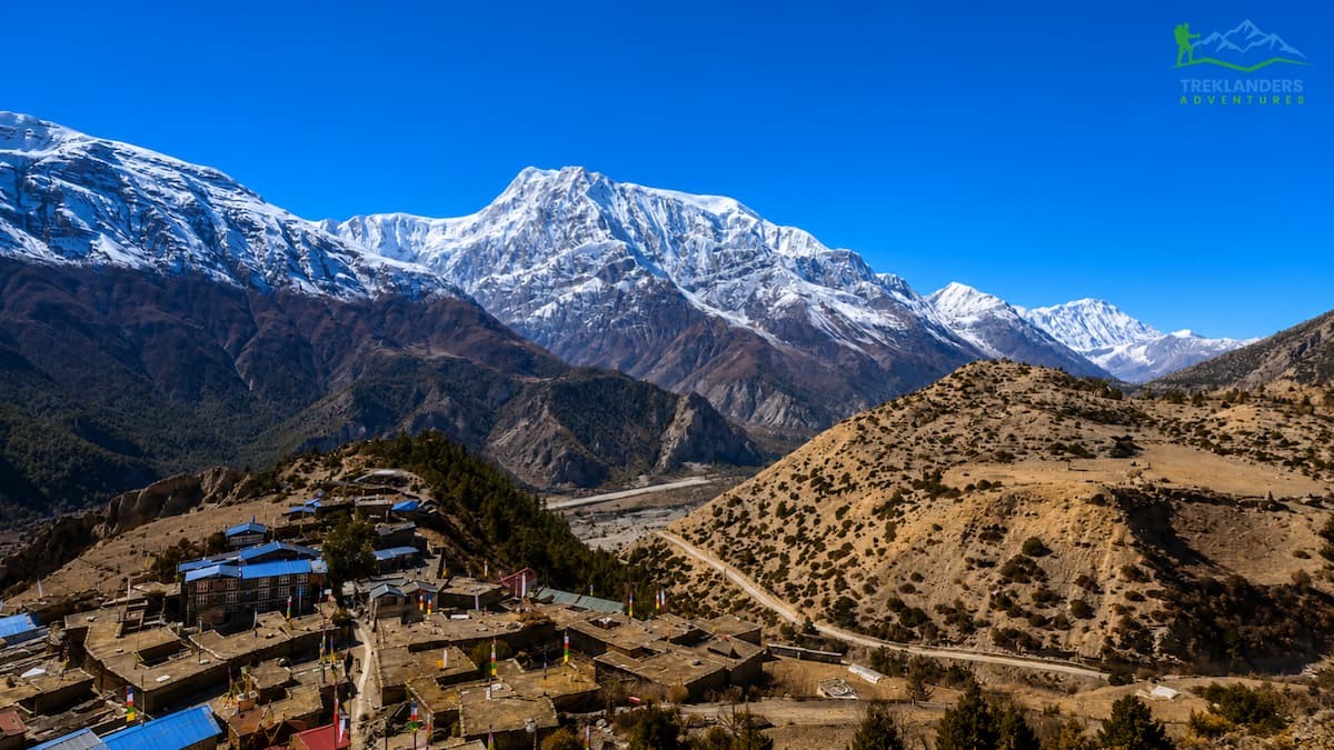
The Annapurna Circuit trek covers some of Nepal's most culturally diverse neighborhoods. The Gurung community mainly lives in the lower foothills near Lamjung. When you ascend to Manang, the communities change to the Manang tribe, a culture which is very much a Tibetan Buddhist one. Prayer wheels, mani stone walls, prayer flags of different colors spread on the roofs, and the well-known Braga Monastery at Manang are the main features of this transition.
The Mustang district is mainly inhabited by the Thakali people, who are traders and innkeepers and have a history of settlement along the old salt route between Nepal and Tibet. The trek's final stop, Jomsom, is located in the heart of Thakali territory. Here, the culture nods to the Buddhist traditions as well as the commercial heritage of the salt trade.
The tea house options around the circuit are really extensive. You will see the usual dal bhat with fried rice, noodles, soup, pasta, egg dishes, pancakes, bread, and Sherpa stew. Some lodges serve apple finish products, including rakshi, and you can get hot apple cider at some restaurants in Manang. For fresh bakery items, go to those who have these at their food establishments. Menus at Tilicho Base Camp and High Camp are generally limited due to the logistics of the supply chain, but there are always hot meals available.
Dining rooms are the focal points of social activities in each tea house, where, in the evenings, trekkers come together around the central stove. Part of the charm of the circuit is sharing the day's ups and downs with fellow trekkers from all over the globe. Because tea house trekking is inherently communal, you find yourself spending your evenings with people from Germany, the US, South Korea, Australia, and even more countries, all following the same itinerary and often exchanging information about route conditions, tips, and encouragement. The social aspect is actually one of the things that makes the Annapurna Circuit unique in comparison to other, more isolated trekking experiences.
Manang Valley rest day is a glimpse of this culture, specifically. Short walks to Gangapurna Lake or viewpoints above the village, a visit to the Braga Monastery with its ancient murals and texts, and a stroll among Manang's densely packed stone houses will give you a memorable acclimatization day. The Himalayan Rescue Association runs an altitude sickness clinic in Manang during the high season, and a free information session on AMS prevention is usually held there. Treklanders advise getting there for this session as an additional preparation measure.
Trekkers often wonder about which challenge is tougher. The truth is that it depends on what kind of challenge you're talking about.
Physically, Tilicho Lake is a lot harder if you look at individual days. The path from Tilicho Base Camp to the lake is not only steep but also very exposed and technically challenging underfoot. The mixture of areas covered with loose stones, a narrow ridge path, and the high altitude of 4,919 meters makes it the part where you need the most technical skills in the whole circuit. In case you don't like heights or exposed areas, the way to the lake will be the one to challenge you more directly than the pass.
When we talk about sustained effort and scale in the broadest sense, Thorong-La Pass is the most difficult. The day of the pass is the longest one in the whole trek, sometimes going up to 7 or 8 hours. You first go up from 4,900 meters at High Camp to 5,416 meters at the pass, and then you go down 1,600 meters to Muktinath. The combination of an early start, cold, altitude, and length makes it the most unforgettable and most demanding day of the circuit. It's also the day that the majority of trekkers recall most clearly afterwards.
Together, they form the two pillars of the full Annapurna Circuit. Neither is the more important milestone. Both are defining moments. The lake rewards you with visual drama and a sense of genuine remoteness. The pass rewards you with a panoramic scale and the satisfaction of crossing the highest point of one of the world's classic trekking routes.
Treklanders build both into the 15-day itinerary for a reason: the full circuit is greater than the sum of its two highlights. The days between the highlights, walking through Manang Valley, visiting the Braga Monastery, watching Gangapurna Himal at dawn from a tea house dining room, are equal parts of what makes this trek worth doing.
Dingboche vs Pheriche: Which acclimatization stop is better for a safer and more successful Everest Base Camp Trek?
Discover the best time to trek the Langtang Valley after monsoon with trail conditions, weather, and essential safety tips.
Everest Base Camp or Cho La Pass? Compare both routes to choose the best Everest trekking experience in Nepal.