9-Day vs 12-Day Everest Base Camp Helicopter Trek: Which Fast-Track Everest Trek Is Best for You?
3 Jun 2026
Compare the 9-Day and 12-Day Everest Base Camp Helicopter Trek and find the best Everest adventure for your schedule and fitness.
Before booking, every trekker entering the Khumbu region will ask the very same question: which viewpoint actually gives you the better Everest experience, Gokyo Ri or Kala Patthar? Both are located in the Everest region. Both will give you stunning Himalayan views that most people will never see, even once in their whole lives. However, they produce very different experiences, and if you choose the wrong one for your objectives, you may feel like you have missed the whole point.
This is a detailed comparison of both viewpoints based on the main factors: altitude, difficulty, the actual view, trail character, crowd levels, photography, acclimatisation, and cost. At Treklanders, we lead trekkers to both summits every season, and our team members have walked every meter of both routes. Below is a straight, detailed comparison based on that experience.
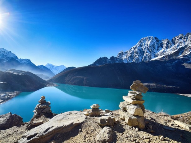
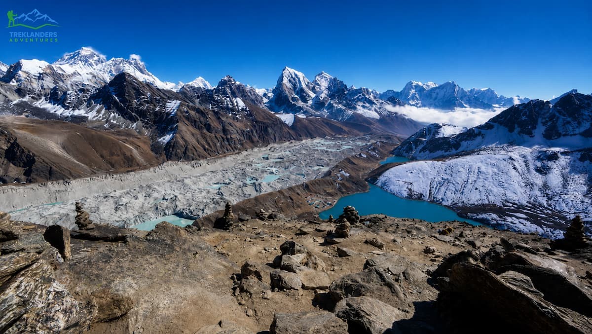
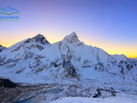
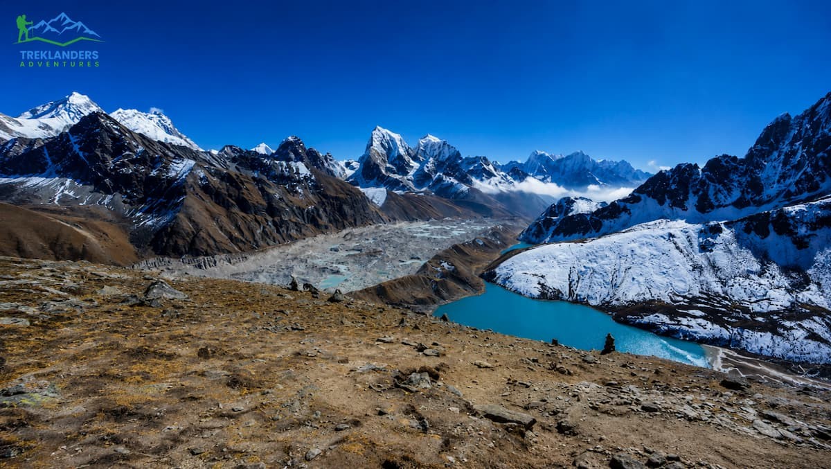
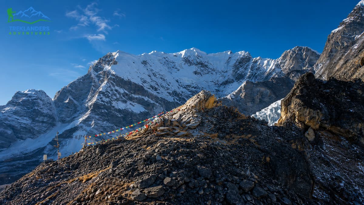
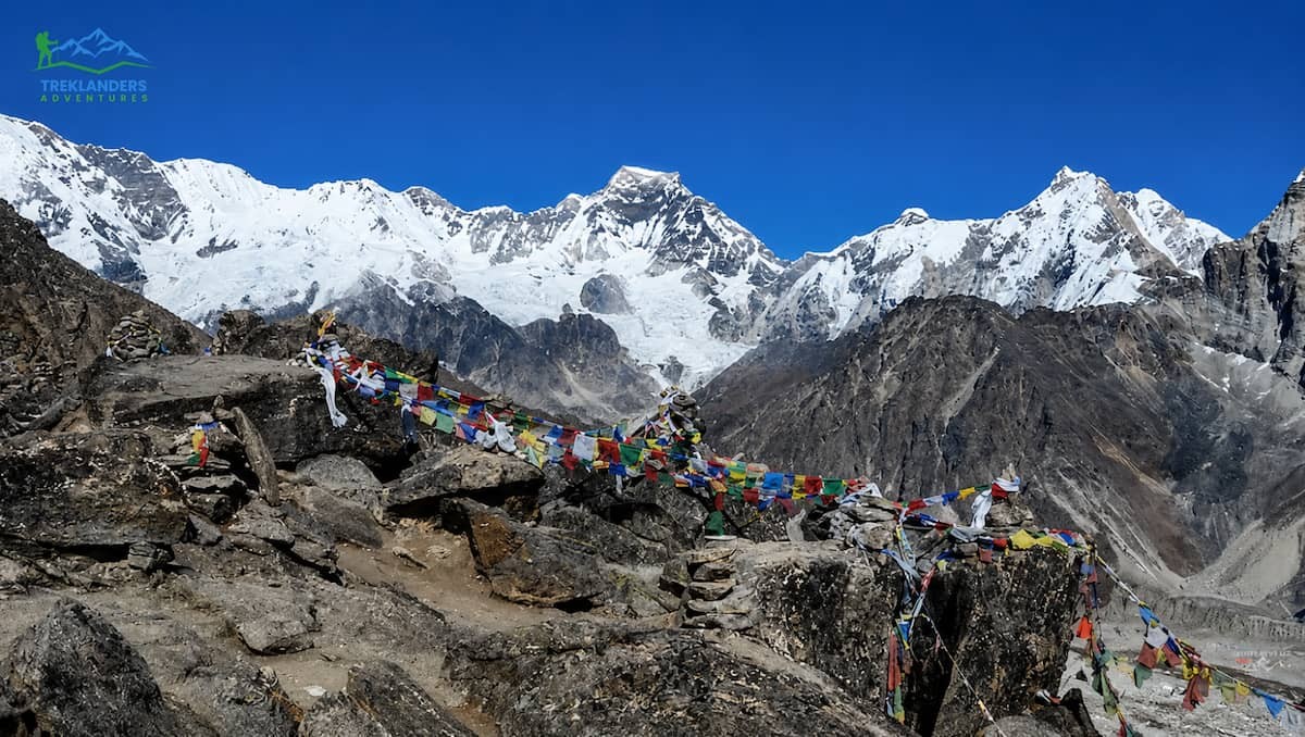
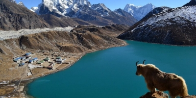
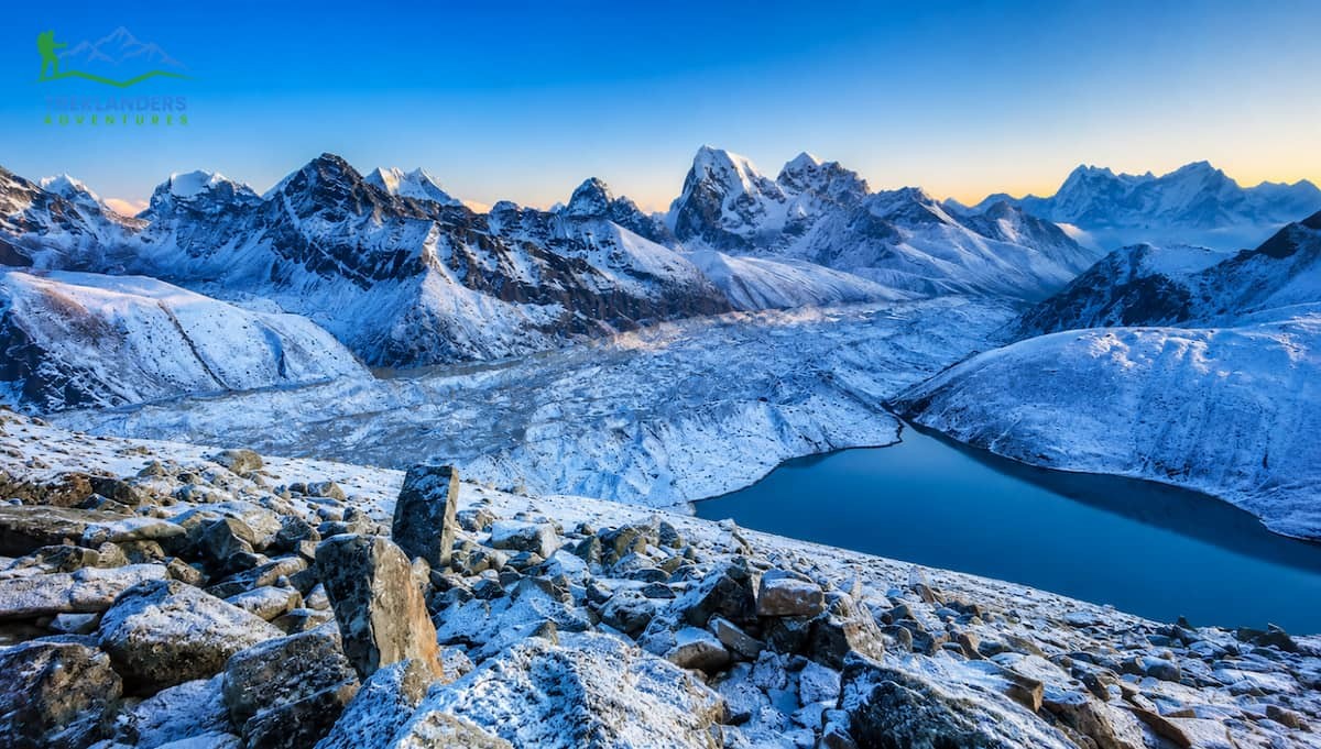
Located on the western side of the Khumbu, Gokyo Ri overlooks the Gokyo Valley. It has a height of 5, 357 meters (17,575 feet) and directly overlooks the Gokyo Lakes, a series of high-altitude glacial lakes located within Sagarmatha National Park. From the top, the giant Ngozumpa Glacier, the largest glacier in Nepal, lies below, and the view extends to Everest, Lhotse, Makalu, Cho Oyu, and several other surrounding peaks. The Gokyo Valley is isolated, rarely visited compared to the main Everest Base Camp route, and it is considered by many to be one of the most beautiful trekking areas in the Himalayas.
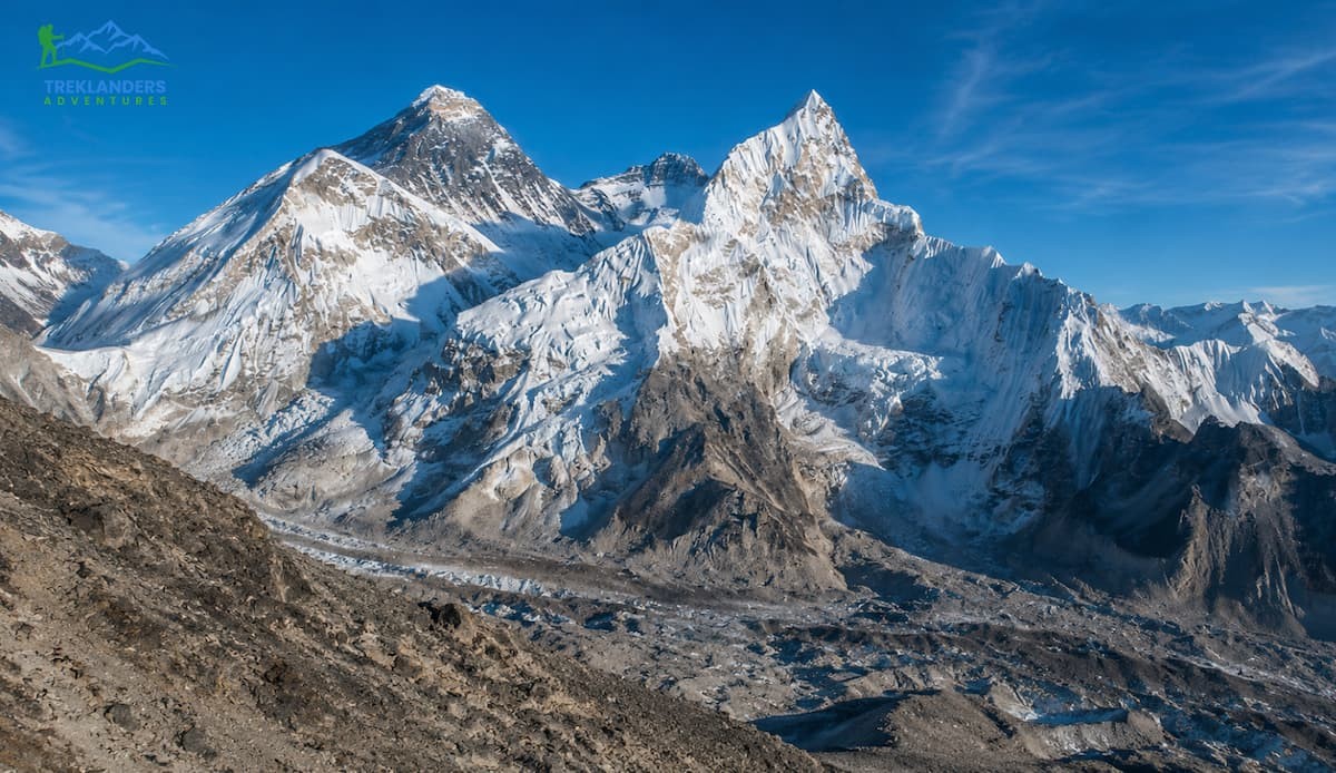
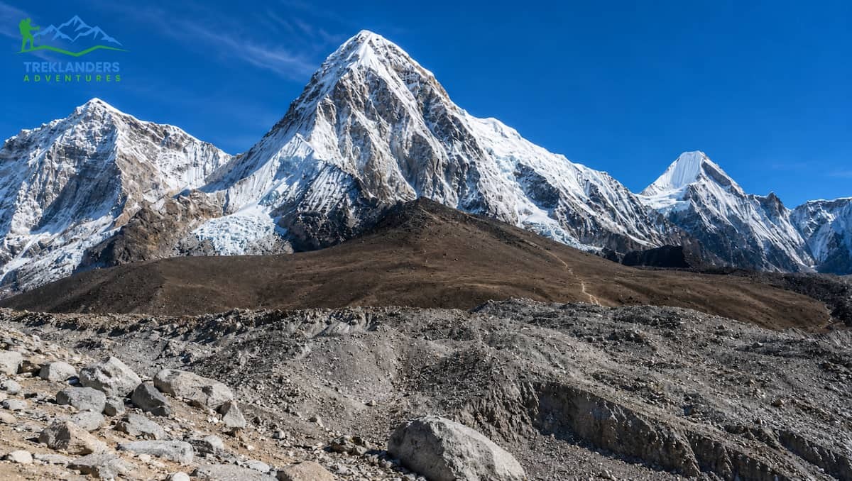
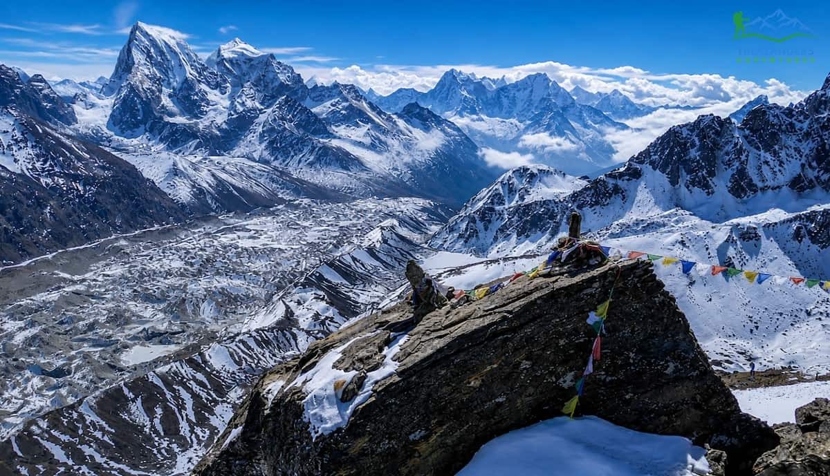
Kala Patthar is located at a height of 5,545m (18,192ft) on the southwestern side of Pumori mountain, overlooking Gorakshep, the last village on the way to Everest Base Camp. It is the commonly chosen high-altitude summit on the classic Everest Base Camp trekking route. From its summit, you have a spectacular view of Everest right before your eyes, with its southwest face seen along with the Khumbu Icefall below and the South Col that is barely visible from the ridge above. Due to its incredible visual portrayal of Mount Everest, Kala Patthar is widely considered one of the most famous trekking summits in the world.
Both of the mountains are more than 5,300 meters high. Attempting the summit without proper acclimatization may be very dangerous for both. Both give you a chance to be rewarded for the early wake-up with the beautiful light and the clearest sky. Besides these few straightforward similarities, the two adventures are totally different in all other aspects.
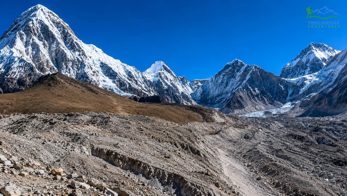
Kala Patthar is actually 188 meters above Gokyo Ri. At these altitudes, the difference of 188 meters is significant. Kala Patthar is located at 5,545 meters, which is pretty much at the top of the list for the highest summits without technical climbing that a fairly fit and acclimatized trekker could attempt in Nepal. At Kala Patthar, you have really gone into the altitude zone where the chances of experiencing symptoms of altitude sickness escalate quite a bit. The climb from Gorakshep is very steep, the path gets rocky and loose in places and being out in the cold before dawn at this altitude can be quite harsh, especially in October and November.
From Gorakshep (5,164 m), the path to Kala Patthar goes up by about 380 meters along roughly 1.5 to 2 kilometers. The slope is quite steep all along. The majority of trekkers choose to start their hike somewhere between 3:00 AM and 4:30 AM so that they can reach the summit before or right at sunrise. The wind at such altitudes is very strong, and it can penetrate even the best layered clothing. On a day when the summit is reached and there is a strong wind, the cold can really become dangerous if trekkers are not well-prepared or under-dressed.

Gokyo Ri is a steep climb up a grassy and rocky ridge from the village of Gokyo at 4,790m to the summit at 5,357m. The altitude gain is around 570m, and the distance is about 2-2.5 km. At a steady pace, a climb will usually take two to three hours. Typically, the wind at the Gokyo Ri summit is less severe than at Kala Patthar. One of the reasons is that valley geography offers a bit more shelter from the prevailing winds.
Physically, in terms of exertion and altitude-related risk, Kala Patthar is more challenging. The combination of higher elevation, thinner air, steeper final approach, and usually colder and windier weather results in a greater physical challenge. It is not a walk in the park to get to Gokyo Ri. Trekkers who underestimate it due to its lower elevation still face a struggle on the summit day. However, the difference in difficulty between the two is quite significant, and for most trekker profiles, Gokyo Ri is the easier of the two.
If you had a case of acute mountain sickness or this is your first time trekking at high altitude, Gokyo Ri is the safer option. On the other hand, if you want the experience of a personal achievement of standing at almost 5,550m, an altitude that very few non-climbers have been to, Kala Patthar is the way to go. Gokyo Ri can't deliver that milestone.
This is the main point, and therefore, let's give a direct answer instead of hedging.
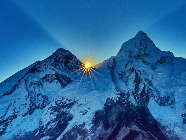
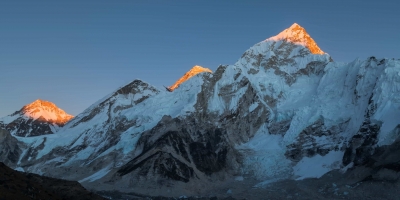
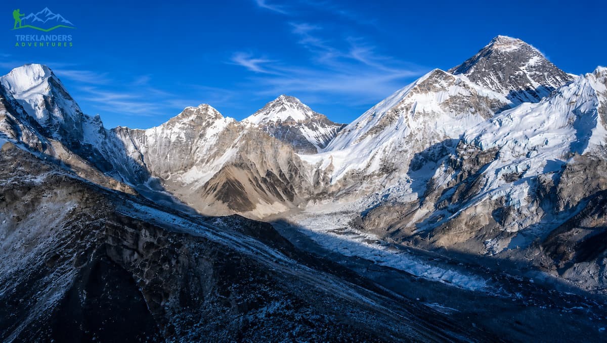
Kala Patthar provides you with a very close, face-on, and visually dominant perspective of Everest. At 5,545 meters, the view of Everest's southwest face is almost head-on. The mountain occupies a major part of your field of vision. You can observe the Khumbu Icefall flowing out of the Western Cwm (the "Valley of Silence"), the South Col ridge travelling across the upper parts of the mountain, and the summit pyramid towering above everything else. If the weather is good and the sun rises with alpenglow touching the peak, it is undoubtedly one of the most visually striking mountain views on earth.
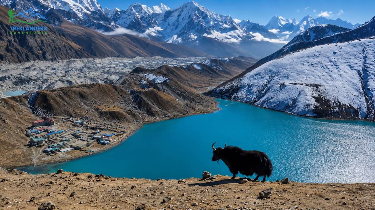
Gokyo Ri, on the other hand, offers a wider and more panoramic view where Everest is just one of the many peaks rather than the single dominant focus. From Gokyo Ri, Everest is located in the southeast; it can be easily recognized and is still quite impressive. However, it shares the skyline with Cho Oyu (8,188 m) to the northwest, Makalu (8,485 m) and Lhotse (8,516 m) flanking Everest, besides numerous other peaks above 6,000 and 7,000 meters. The Ngozumpa Glacier extends for kilometers through the valley, and the Gokyo Lakes reflect the sky on clear days.
Whether one view is objectively better depends on what you want from the experience.
If your goal is to see Everest as the centerpiece, imposing and close, Kala Patthar wins that comparison. The mountain commands the view in a way that nothing else does at Kala Patthar. Many dedicated mountain photographers prefer Kala Patthar specifically because of how the peak dominates the composition and how the alpenglow moves across the face at dawn.
If your goal is to get an idea of the Khumbu as an entire mountain system, see the scale of the glaciation, the sequence of peaks, the relationship between valleys and ridges and summits, then Gokyo Ri is the better option. There is more of the Himalaya visible from Gokyo Ri in a single view than from almost any other reachable point in the Everest region. The summit offers a full circle panorama, and on a clear day, the view northward over the Tibetan plateau adds yet another dimension.
A viewpoint isn't simply about reaching the summit; it's the whole experience of the journey that covers every valley, village, glacier, and ridgeline you encounter before getting there.
The typical Everest Base Camp route to Kala Patthar goes through Namche Bazaar, Tengboche, Dingboche, Lobuche, and Gorak-Shep. For a large portion of the upper route, you will be walking along the Khumbu Glacier. At Tengboche, you can see the famous monastery, which is one of the most revered Buddhist sites in the Himalayas and is located on a ridge offering a spectacular view of Ama Dablam. You will also come across Sherpa villages, locations which have been the heart of Everest expedition logistics for more than a century. This route is steeped in history, is well-developed, and fully supported by a tight network of teahouses providing good food and comfortable lodging.
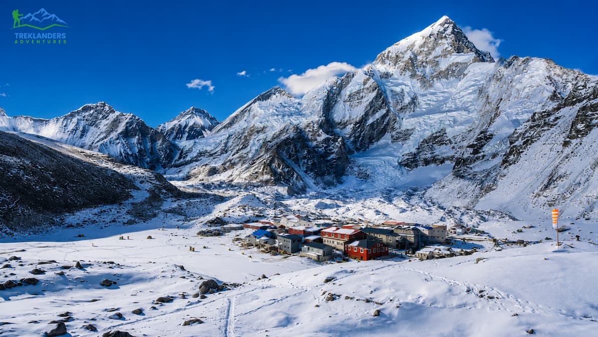
Importantly, the EBC path is the one that leads you to the Everest Base Camp itself, located at an altitude of 5,364 meters on the edge of the Khumbu Glacier. A trip to EBC not only lets you see the base camp area for Everest expeditions but also the tents of climbing teams during the season, and you even get that feeling of standing at the base of the highest mountain in the world. Most Kala Patthar trekking plans include a visit to EBC and the summit, so you get two fantastic experiences along the same trail.
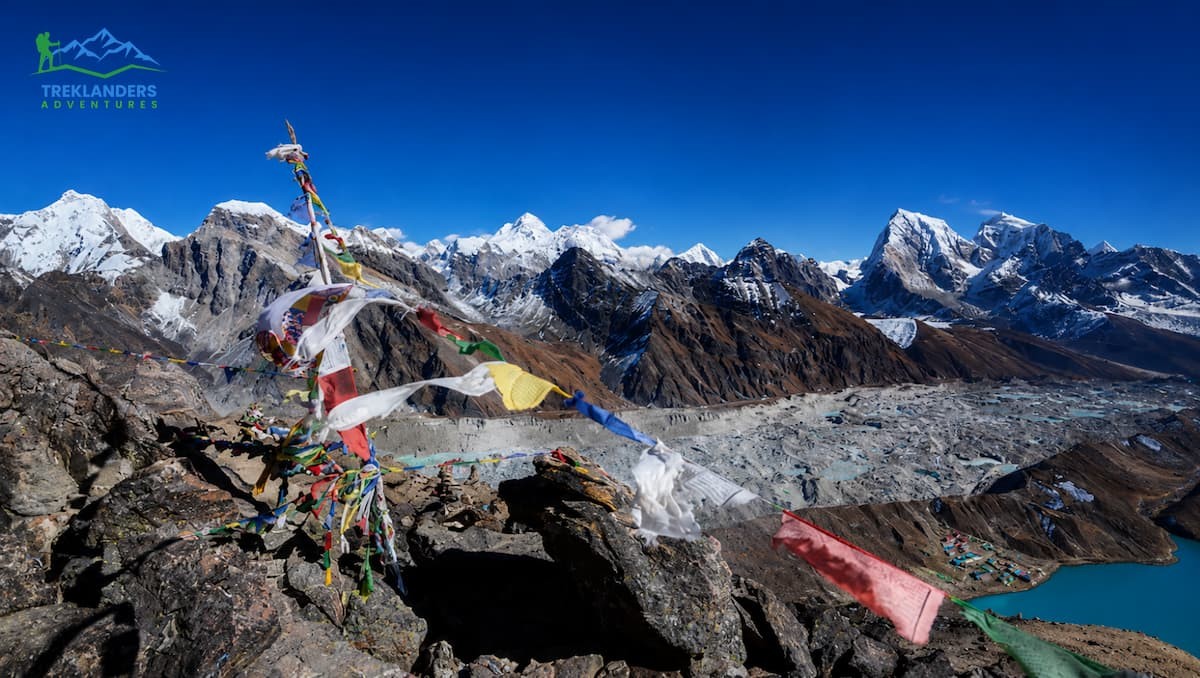
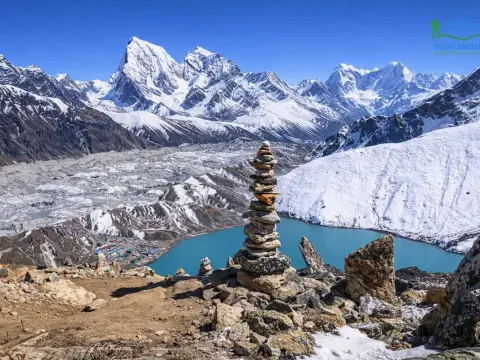
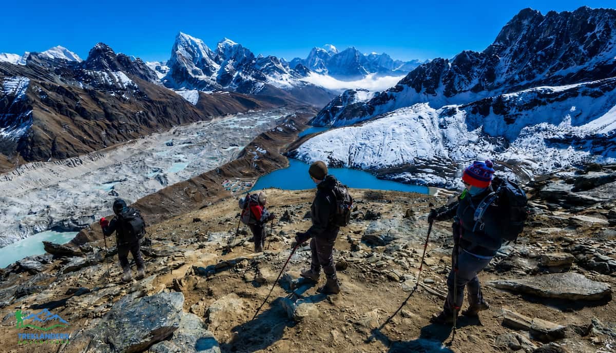
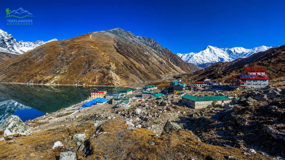
The Gokyo Valley route to Gokyo Ri passes through Namche Bazaar, Dole, Machhermo, and Gokyo village. The trail is quieter, receives far fewer trekkers than the main EBC route, and feels more remote as you move deeper into the valley. You pass yak pastures and herder huts, walk alongside the Ngozumpa Glacier, and stop at each of the Gokyo Lakes as you ascend through the valley. The lakes themselves are striking, high-altitude turquoise pools surrounded by glacier moraine and towering peaks. First Lake, Second Lake, Third Lake, and the main Gokyo Lake (Fourth Lake) each has its own character.
The Gokyo Valley route does not include Everest Base Camp, which is a genuine trade-off. If standing at EBC is a personal goal, the Gokyo route alone does not fulfil it.
Trail traffic is a tangible part of the Khumbu experience, and the two routes vary greatly in this respect.
The route to Everest Base Camp is one of the most frequent trekking circuits on earth. During the main seasons (October to November, late March to May), the trail from Namche to Gorakshep is thronged with thousands of trekkers each week. Gorakshep is a small village with a few lodges, and at the busiest times it seems almost overwhelmed. The teahouse rooms get fully booked. If you are to the summit of Kala Patthar before dawn in October, you might find yourself in a long queue of headlamps that extends far up the ridge. The communal dining rooms at the major lodges are often filled and loud.
Only a very small number of visitors come to Gokyo Valley, simply because the area and the distance put off those walkers who are not specifically set on the valley. After Machhermo, the path is really very peaceful. Of course, there will be some others as well on the Gokyo Ri peak at sunrise, but the crowd is much less than on Kala Patthar during the same week of the peak season. Usually, on any day of the year, you can find a seat at a teahouse in Gokyo very easily.
A quiet, peaceful environment with few people is a very central aspect of how you enjoy being in the mountains; the Gokyo route gives you that far more than the other. On the other hand, if you feed off the excitement and social aspects of a busy trail, the EBC route is the place to be for that, and lots of trekkers have a lot of fun with the friends they make on a popular trail.
Both places provide excellent conditions for photography at the highest level in the world. They favor different styles of shooting and different subjects.
Kala Patthar is the typical summit for Everest photography. Going up before dawn for a sunrise gives the entire sequence: a dark approach, the first light striking the summit pyramid, the alpenglow going down the face, and then full morning sun lighting up the Khumbu Icefall below. Everest is the main focus at Kala Patthar, which makes the creative choice much easier. Wide-angle and standard focal lengths are good. The foreground is rocky and minimal, keeping the main focus of the picture on the mountain.
Gokyo Ri provides more compositional opportunities in each shot. Besides the Gokyo Lakes that can be used as foreground elements, you can see them from the ridge below the summit. Njozumpa Glacier makes an interesting mid-ground texture across the valley. Almost the entire 360-degree panoramas are covered by a semicircle of major peaks. Cho Oyu, the 6th highest mountain in the world, is very close to the northwest, and the morning light on its face from Gokyo Ri can be outstanding. Gokyo Ri, in fact, offers more scenes to tell a story for landscape photographers working on the Khumbu.
The golden hour at both summits is very brief, and the weather can change quite quickly. Clouds usually accumulate from noon during both seasons. If you get to the summit at or just before the break of dawn, you will get the clearest views and the most beautiful light.

Both summits demand serious acclimatization. Attempting either without proper altitude preparation is the leading cause of failed summit attempts and altitude sickness in the Khumbu.
The EBC route to Kala Patthar has a well-established acclimatization structure. Standard itineraries include a rest day at Namche Bazaar (3,440 m) and an acclimatization day in the Dingboche (4,410 m) and Lobuche (4,940 m) zone before reaching Gorakshep and attempting the summit. By the time most trekkers push to Kala Patthar, they have spent eight to ten days progressively ascending through the Khumbu. That foundation matters enormously at 5,545 meters.
The acclimatization profile for the Gokyo Valley route is a bit different from the other route. Typically, there will be an acclimatization day at Machhermo (4, 470 m) followed by a trip to Gokyo (4, 790 m). After a rest day at Gokyo village, the summit day on Gokyo Ri can be scheduled. The summit day on Gokyo Ri should be the next day after at least one full rest day at Gokyo village. Some people decide to spend an extra day at Gokyo before tackling the summit, especially if they have faced any symptoms due to altitude earlier on the route.
Both routes share the same basic principles: you should raise your elevation slowly, drink plenty of water, take your meals even if your appetite is low, try to sleep at an altitude that is lower than your highest daily ascent whenever this is possible, and only use acetazolamide if it is prescribed and directed by a doctor familiar with altitude medicine.
Treklanders is committed to ensuring proper acclimatization in all its Everest region itineraries. Our guides are equipped with pulse oximeters and check oxygen saturation levels daily at altitude. Trekkers with oxygen levels that are below safe limits are not allowed to go to higher elevations until they are fully recovered. This is an absolute policy on all Treklanders' itineraries, not a mere recommendation.
Choosing one or the other is not necessary. You can actually combine the Everest Base Camp and Gokyo Valley route together, and your trek will be 18 days long, starting at USD 1,405 (Group Discounts). This way, you get to experience both the highlights.
The trek first follows the Gokyo Valley to the village and the Gokyo Ri summit, then comes the crossing of the Cho La Pass (5,420 m) to the main EBC corridor. Along the way, you reach the Everest Base Camp and Kala Patthar summit. Cho La Pass crossing is actually the technical challenge of this route. The pass has glacier travel and comes with a descent where microspikes or crampons are necessary. It is doable for fit, well-acclimatized trekkers who have altitude experience; after all, first-time high-altitude trekkers without proper experience should definitely avoid this route.
This combination itinerary is what Treklanders recommend most consistently to trekkers who have the time and fitness to complete it. You experience the Gokyo Lakes and the panoramic summit view from Gokyo Ri. You cross the Cho La and feel the full geological scale of the Khumbu. You stand at Everest Base Camp. You climb Kala Patthar and look directly at Everest from less than 4 kilometers away. No single-route itinerary in the Khumbu covers more high-quality terrain.
The Everest Three Passes Trekking is the maximum version of this approach, crossing all three high passes of the Khumbu (Renjo La, Cho La, Kongma La) over 22 days from USD 1,635(Group Discounts). It covers every major valley and viewpoint in the Everest region in a single continuous route. It is the most demanding non-technical Himalayan trek Treklanders offers.
Choose Kala Patthar if you:
Choose Gokyo Ri if you:
Choose the combination route if you:
Best seasons: The weather moments are most stable during October to November and March to April. You get the most reliable, clear pre-dawn skies in October and early November. March changes the normal day's length for more daylight and more warmth but can also bring more unsettled weather as it is the transition time from winter.
Permits: You need a Sagarmatha National Park Entry Permit and a Khumbu Pasang Lhamu Rural Municipality Permit to do either of the routes. Treklanders will take care of all the permits before your trek starts.
Flights to Lukla: Both routes commence with a flight from Kathmandu to Lukla. The flight duration is about 35 minutes, and it depends on the weather. It is advisable to plan some buffer days at the beginning of your itinerary, especially if your international flight has a tight connection.
Guides: All Treklanders Everest region treks include a TIMS-certified, English-speaking guide with high-altitude first aid certification. A porter is included to carry a share of your gear, allowing you to walk at a comfortable pace without overloading your body at altitude.
Where you sleep and eat on a Himalayan trek influences your recovery, acclimatization, and overall experience. The two paths offer different things.
The EBC trek is the most serviced trekking route in Nepal. Tea houses are plentiful, and when competitive, the standards keep going up. Namche Bazaar has bakeries, espresso, hot showers, and fast Wi-Fi in several lodges. Even at Lobuche and Gorakshep, the tea houses are working and getting better regularly, with proper bedding, device charging points, and hot meals. The food options at the lodges along the EBC path are more diverse than on most other Nepal treks. You can have dal bhat, pasta, pizza, eggs, and soup at most stops.
On the other hand, the main disadvantage is that the high traffic means that the best rooms get occupied early. When the season is at its peak in October, those who get to Gorakshep in the afternoon sometimes find there are no single rooms left, and they are directed to dormitory-style accommodations. Booking lodges in advance through your trekking company is a solution to this, and Treklanders arranges accommodation along the whole route before departure.
The Gokyo Valley path hosts fewer teahouses and fewer trekkers; thus, a totally different vibe arises.
Comfortable accommodation is plentiful in Gokyo village, with a range of lodges having different prices. Generally, food quality is quite high, and you will be served typical Himalayan food: dal bhat, noodle soup, potatoes, eggs, and tea. Although the variety is less on the EBC route, the food is still hot and enough to give you energy for the trek.
The trail from Machhermo to Gokyo has only one lodge at Luza. Faster trekkers should confirm with their guide about lodging availability between different stages. Treklanders have done the Gokyo itinerary in such a way that overnight stays correspond to where comfortable lodges are available.
What's more, an actual benefit of the Gokyo route is that the lesser crowd pressure there means you'll probably get a private room at every lodge and have more tranquility in the shared spaces during evenings. Gokyo lodges provide a real change for those who are tired of the social atmosphere of the EBC teahouses.
Both routes have reliable mobile phone network coverage (NTC and Ncell) through most of the main villages, though connectivity becomes patchy at high elevations. Wi-Fi is available at lodges in Namche, Tengboche, Dingboche, Gokyo, and Gorakshep, with varying quality. Do not plan to work remotely from any of these locations above 4,000 meters; treat any connectivity as a bonus rather than a given.

Planning a trek to the summit at either time requires knowledge of how seasonal conditions impact these high-altitude viewpoints. October and November are post-monsoon months and are considered by most to be the best months for trekking in the Everest region. After the monsoon retreats in late September, the skies get clearer, the weather patterns come to rest, and the mountain views are often spectacular. October has the greatest probability of sunrise being free of clouds, yet it is also the month that sees the biggest number of trekkers, mainly on the Everest Base Camp route.
November presents almost equally good stable weather, but with significantly fewer people. On the other hand, the temperature plummets, going up to 4,500 meters and higher, where at night it can even get too minus 15 degrees Celsius or further. Having good quality winter sleeping bags, warm clothes, gloves, and face protection will be very necessary.
Spring, the season from the end of March till May, is characterized by increasing warmth and lengthening of days. The weather is still good, but the clouds tend to build up sooner than before. About the area where rhododendron forests are blooming, those valleys are at a low elevation.
Winter months from December to February remain possible for experienced trekkers with appropriate equipment, though extreme cold and limited teahouse services are common.
Monsoon season from June to August is generally unsuitable because of heavy rain, muddy trails, leeches, and poor visibility, despite slightly drier conditions on the Gokyo route.
Gokyo Ri and Kala Patthar must not be compared as they are completely different ways to feel the Khumbu Himalaya.
Kala Patthar offers the closest and most stunning view of Everest to trekkers. Standing at the edge of the vast Khumbu Glacier with Everest right above, and the Base Camp of the Mountain rarely far away, it is the typical experience of Everest. Besides, standing at almost 5,550 meters means you will have gone quite high up in altitude too, without requiring any technical climbing.
Gokyo Ri shows a much wider and differently laid out view. The bright blue Gokyo Lakes, the sprawling Ngozumpa Glacier that looks like an icy river, and views of Cho Oyu make it a place you will not locate anywhere else in that area. The path tends to see less traffic, and the top gives a 360-degree view of a number of the Himalayan giant peaks simultaneously.
Both places reach the top of the best trekking viewpoints worldwide. Choosing the classic Everest view of Kala Patthar or the more extensive mountain panorama of Gokyo Ri, you will stand in a place where few have ever been.
Khumbu is calling. The only thing is, which summit will be your first visit to?
Compare the 9-Day and 12-Day Everest Base Camp Helicopter Trek and find the best Everest adventure for your schedule and fitness.
Compare the Tamang Heritage Trail and Langtang Valley Trek for culture, villages, and stunning Himalayan views in Nepal.
Compare Thorong La Pass and Kongma La Pass to discover which Himalayan trekking pass is harder, higher, and more challenging.